


The Nature Conservancy's largest ever gift will preserve 24,000 acres of highly prized land in California. Jack and Laura Dangermond (cofounders of Esri) made the donation.
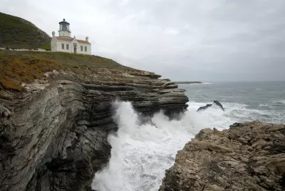
James Fallows reports: "A renowned tract of undeveloped California coastal land totaling more than 24,000 acres, or about 38 square miles, has been purchased by The Nature Conservancy (TNC) for permanent preservation, thanks to a $165 million donation by a wealthy tech-industry couple."
The tract of land (now called the Jack and Laura Dangermond Preserve, but previously called the Bixby Ranch) "includes hills and canyons, grasslands and brush, 2,000 acres of coastal live-oak stands containing perhaps 1 million trees, a creek, parts of the Santa Ynez mountain range—and a full eight miles of the bluffs and beaches that make up the coastline around Point Conception, west of Santa Barbara."
The tract is rare for its size and its mostly natural state. The land has never been subdivided, and now it never will.
FULL STORY: A Historic Gift of Pristine Land to Inspire Tech's Elite

Can Conservation and Drilling Coexist?
That's the question facing the nation's largest environmental organization (not the Sierra Club but The Nature Conservancy) regarding the management of its preserve in Texas. There is no question for Naomi Klein, who writes about it in her new book.
BLM To Rescind Public Lands Rule
The change will downgrade conservation, once again putting federal land at risk for mining and other extractive uses.
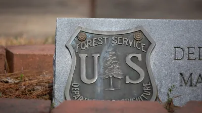
What Forest Service Cuts Mean for Cities
U.S. Forest Service employees work on projects that have impacts far beyond remote, rural wilderness areas.

Alabama: Trump Terminates Settlements for Black Communities Harmed By Raw Sewage
Trump deemed the landmark civil rights agreement “illegal DEI and environmental justice policy.”

Planetizen Federal Action Tracker
A weekly monitor of how Trump’s orders and actions are impacting planners and planning in America.

The 120 Year Old Tiny Home Villages That Sheltered San Francisco’s Earthquake Refugees
More than a century ago, San Francisco mobilized to house thousands of residents displaced by the 1906 earthquake. Could their strategy offer a model for the present?

Ken Jennings Launches Transit Web Series
The Jeopardy champ wants you to ride public transit.

BLM To Rescind Public Lands Rule
The change will downgrade conservation, once again putting federal land at risk for mining and other extractive uses.

Indy Neighborhood Group Builds Temporary Multi-Use Path
Community members, aided in part by funding from the city, repurposed a vehicle lane to create a protected bike and pedestrian path for the summer season.
Urban Design for Planners 1: Software Tools
This six-course series explores essential urban design concepts using open source software and equips planners with the tools they need to participate fully in the urban design process.
Planning for Universal Design
Learn the tools for implementing Universal Design in planning regulations.
Clanton & Associates, Inc.
Jessamine County Fiscal Court
Institute for Housing and Urban Development Studies (IHS)
City of Grandview
Harvard GSD Executive Education
Toledo-Lucas County Plan Commissions
Salt Lake City
NYU Wagner Graduate School of Public Service