


As the state's worst wildfire season ever refuses to end, an analyst from UCLA considers how land use and building codes determine the location and extent of the damage.
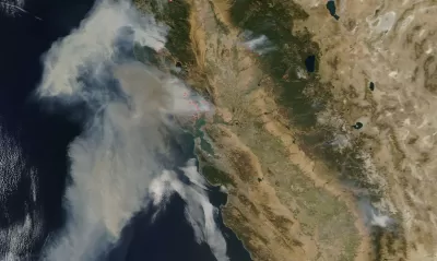
As one of the worst wildfires in California history continues to extend the state’s worst wildfire season, Faith Kerns at The Conversation notes that which houses burn and which don’t is more predictable that it may seem.
While “[i]t is commonly thought that it takes direct flame to spread a fire,” she writes, it’s often embers that are to blame.
“These small bits of burning debris can be lofted long distances by the wind. They can then end up igniting landscaping materials like combustible mulch, or enter homes through vulnerable spots – gutters teeming with debris, unscreened attic vents, open or broken windows, old roofs with missing shingles.”
The damage to homes is also deeply affected by whether or not those areas are thought to be at risk, and whether or not building codes reflect that. Measures to decrease the damage to homes caused by wildfires can include regulations on building materials and building codes.
"Researchers recommend what is known as a “coupled approach” to home and building survival. This means the development and maintenance of an effective defensible space, as well as the careful selection of construction materials and correct installation to ensure that, for example, there are not gaps in siding or roofing that would allow embers to penetrate."
But in a state where there’s usually a building boom somewhere, the most effective method of prevention is also the most painful.
“Decision-makers also need,” Kerns writes, “to be willing to take on the most taboo topic of them all: recognizing that there are places houses simply shouldn’t be built, or rebuilt, at all.”
Seasonal wildfires have always part of the ecology of much of California, but they are becoming more frequent and more intense, in part due urban sprawl (the Wildland-Urban Interface) and in part due to climate change.
“It’s not something that we should, or ever could, hope to fully contain,” Kerns writes. “Our only chance is learning, really and truly and finally learning, to live with it.
FULL STORY: California fire damage to homes is less ‘random’ than it seem

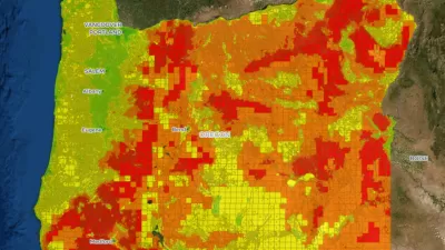
Oregon Issues Wildfire Risk Map
After homeowners received letters assessing their property’s fire risk, questions remain about the next steps in building fire resilience.

UCLA Experts Offer Critical Support for LA Wildfire Response and Recovery
The UCLA Luskin Center for Innovation offers expert guidance on LA wildfire response and recovery, addressing critical issues like water safety, air quality, equitable rebuilding, and climate adaptation to promote resilience and sustainability.
Wildfires Devastate LA Outdoor Education Spaces and Schools
The current Los Angeles wildfires have destroyed schools and outdoor education spaces like Eaton Canyon, displacing families and disrupting vital learning and community resources while highlighting the region’s vulnerability to natural disasters.

Alabama: Trump Terminates Settlements for Black Communities Harmed By Raw Sewage
Trump deemed the landmark civil rights agreement “illegal DEI and environmental justice policy.”

Planetizen Federal Action Tracker
A weekly monitor of how Trump’s orders and actions are impacting planners and planning in America.

The 120 Year Old Tiny Home Villages That Sheltered San Francisco’s Earthquake Refugees
More than a century ago, San Francisco mobilized to house thousands of residents displaced by the 1906 earthquake. Could their strategy offer a model for the present?

Ken Jennings Launches Transit Web Series
The Jeopardy champ wants you to ride public transit.

BLM To Rescind Public Lands Rule
The change will downgrade conservation, once again putting federal land at risk for mining and other extractive uses.

Indy Neighborhood Group Builds Temporary Multi-Use Path
Community members, aided in part by funding from the city, repurposed a vehicle lane to create a protected bike and pedestrian path for the summer season.
Urban Design for Planners 1: Software Tools
This six-course series explores essential urban design concepts using open source software and equips planners with the tools they need to participate fully in the urban design process.
Planning for Universal Design
Learn the tools for implementing Universal Design in planning regulations.
Clanton & Associates, Inc.
Jessamine County Fiscal Court
Institute for Housing and Urban Development Studies (IHS)
City of Grandview
Harvard GSD Executive Education
Toledo-Lucas County Plan Commissions
Salt Lake City
NYU Wagner Graduate School of Public Service