


An examination of the Block Ordinance as a panacea for the ailments of modern cities.

A Future Cities article, titled "Two simple sentences could reshape suburban America," challenges an unthinking acceptance of specific planning ordinances and zoning regulations. The article does so by revealing their origins and by critically assessing their outcomes—offering an invaluable, evolutionary perspective.
Its main argument and the proposed alternative—a Block Ordinance—however, would have been more persuasive if the historical inquiry and the search for alternatives had been expanded. This ordinance deems the block land as private property, surrounded by public land, and restricts its perimeter length to a presumed ideal maximum.
This piece traces a number of historical references and explores experimental alternatives, showing that the Block Ordinance, by itself, is inadequate to guide the laying out of subdivisions.
Great cities, much better cities, better places
First, let’s lighten the burden of good intentions. All planning measures share that motive, but some, usually in retrospect, are shown to have unintended and unwelcome outcomes. The author argues in favour of a simple Block Ordinance for the sake of building "[..] great cities, better cities or better places." Yet, as the article insinuates, contemporary practicing planners, working within existing metropolises, hardly ever "build cities"; they simply try to fix things. Not only the degree of influence is in question but also whether any one specific measure is as indispensable to greatness as proclaimed. History shows cities rising to greatness or falling to insignificance while retaining their layouts, and cities of similar status display sharply contrasting layouts, subverting the importance of planning decisions. The forces that shape a city's quality are far too many and too entangled to simplify them to a "good plan, bad plan" categorization. The article admits that "This [proposed ordinance] won't guarantee great cities but it will preclude horrible cities." We can only hope, given the inscrutable dynamics of cities. For now, let’s avoid the intention of "greatness" and concentrate on causes, effects, and outcomes.
Block history, variations, and outcomes
The article illuminates the intent of the 1928 Department of Commerce publications and unveils their consequences by means of a representative specimen—a plan that obviously limits connectivity.
Here is where this analysis stumbles. It uncovers the genesis and rationale of a recent, ubiquitous planning ordinance but stops short of doing the same for its predecessors. It looks at the negative outcomes of the former but not of the latter. It also stumbles on a core conceptual difference between the existing and the proposed ordinances: the former speaks to the issue of local streets and the latter to the issue of what constitutes a city block. The first incorporates the notion of traffic circulation, the second bypasses it—altogether, apples and oranges.
The idea that a "good" block with a defined maximum perimeter can result in a "better city" excludes the intermediate steps of defining the shape of the block(s), their potential variety and the multitude of ways in which they can be arranged to form a recognizable pattern. A pattern cannot be formed without a generative rule. Even then, a rule-bound pattern may not necessarily constitute a circulation system. Conversely, a preconceived circulation system shapes the blocks between their elements. The blocks are islands in a public realm archipelago and may be irregular, whimsical, and unique.
Here are some examples of layout configurations that illustrate these points.
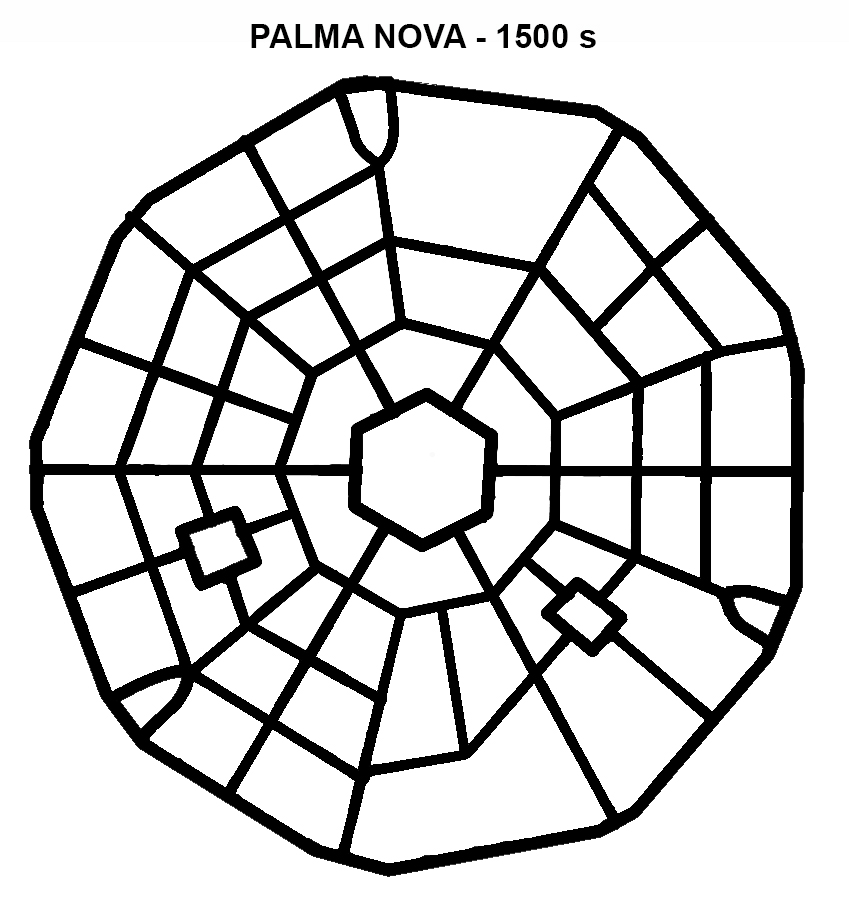
Image 1. Palma Nova (1500 s): In this nine-sided polygon city, diverse blocks emerge from a circulation system. They comply with the "block ordinance" but belong strictly to this system alone and cannot be used independently. Notice that only three radial streets cross the square; the rest are "local."
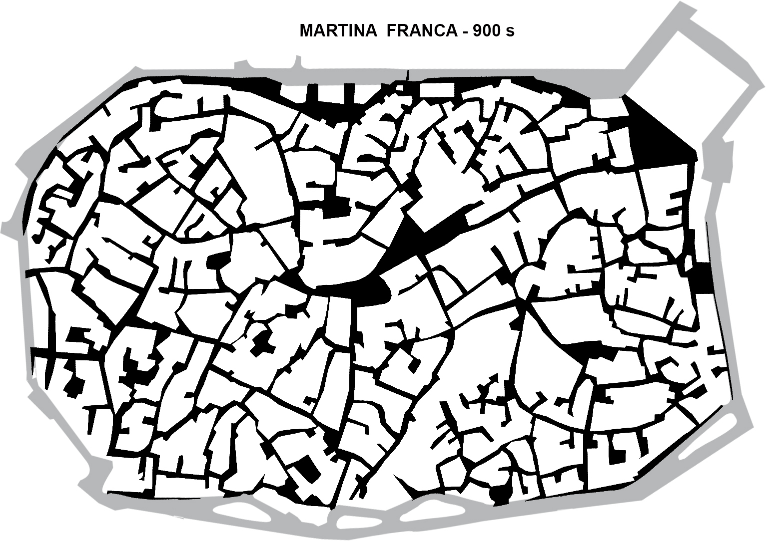
Image 2. Martina Franca (900 s, Italy): No discernible pattern of streets or city block regularity. Each block is unique, shaped by its location in the system and the hilly topography. As with Palma Nova, it is the path system, random as it may be, that defines Martina Franca’s whimsical blocks. The majority of streets are local.
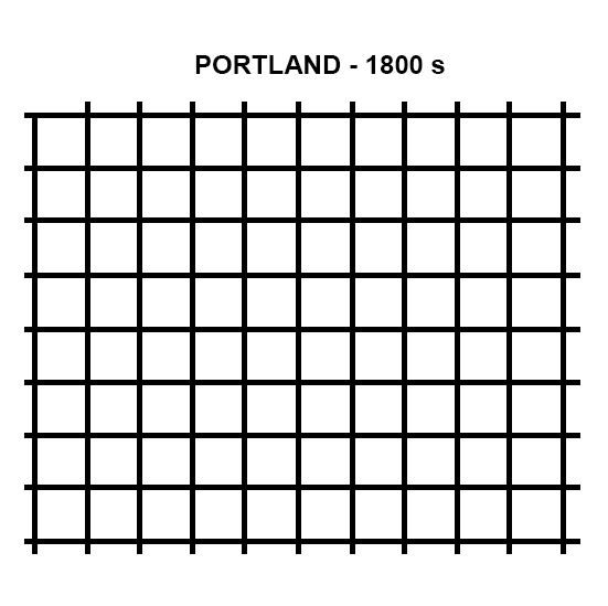
Image 3. Portland (1800 s): In this case, though the blocks result from a T-and-set-square method of subdividing land (similar to Roman garrison towns, e.g., Timgad), the block could be mistaken as the formative element of the plan, which it is not. The block ordinance would seem to be at work here. But its presence is deceptive. It presumes the orthogonal grid generative method of a circulation and access to properties system. Orthogonal, identical blocks its the inevitable outcome. No street is local in this system.
To test the hypothesis that the block ordinance would not necessarily deliver a circulation system without an overarching grid, an orthogonal plan is constructed that includes two typical, fully ordinance-compliant blocks. The blocks are then configured in locked pinwheel patterns or a "basket weave."

Image 4. A hypothetical, experimental layout: Two block sizes (e.g. Portland’s and its double) and a "basket weave" generative rule. All streets are local.
Surprisingly, this layout achieves the objective of local streets advocated by the 1928 "disastrous" ordinance while embedding the proposed "remedy" block ordinance. Even more surprising is that its connectivity index would surpass New York's, achieving the remedy's central objective—connectedness. Yet, clearly, it will not do; something essential is missing—a circulation system.
Image 5. A second hypothetical layout (based on Raymond Unwin’s nested block proposal): It uses a large grid (about 600 x 600 feet e.g. Salt Lake City) as the circulation framework and nested blocks inside it. It generates local streets while keeping the block definition intact. In principle, this option satisfies the premises of both contrasting ordinances. This exploration of options can go much further.
To sum up, this analysis has shown that the city block itself, no matter how well defined and sized, is insufficient to generate a circulation system of which itself is a derivative element. Such a system has to be conceived first. It should, among other issues, answer the question of local streets: their purpose, their definition, and the ways to integrate them into the system, if they have known positive outcomes. A synthesis (or fusion) of the two ordinances is the best way forward.
Fanis Grammenos is the director Urban Pattern Associates in Ottawa, Ontario and the author of Remaking the City Grid: A Model for Urban and Suburban Development.

Did the Pandemic Spur Radical Urban Change?
The Covid era highlighted social inequities and prompted new paradigms for urbanism and mobility. Will they stick around?
Urban Design Through a Gender Lens
Building cities to be safe and accessible for women and LGBTQIA+ people has benefits for all users of public space.
“Completing the Loop” Plan Wins National Award for Excellence in Sustainability
Riverlife and evolveEA were honored by the American Planning Association (APA) for the plan, which outlines a 10-year vision to connect, enhance, and expand Pittsburgh’s network of riverfront parks, trails, and public green spaces.

Alabama: Trump Terminates Settlements for Black Communities Harmed By Raw Sewage
Trump deemed the landmark civil rights agreement “illegal DEI and environmental justice policy.”

Planetizen Federal Action Tracker
A weekly monitor of how Trump’s orders and actions are impacting planners and planning in America.

The 120 Year Old Tiny Home Villages That Sheltered San Francisco’s Earthquake Refugees
More than a century ago, San Francisco mobilized to house thousands of residents displaced by the 1906 earthquake. Could their strategy offer a model for the present?

In Both Crashes and Crime, Public Transportation is Far Safer than Driving
Contrary to popular assumptions, public transportation has far lower crash and crime rates than automobile travel. For safer communities, improve and encourage transit travel.

Report: Zoning Reforms Should Complement Nashville’s Ambitious Transit Plan
Without reform, restrictive zoning codes will limit the impact of the city’s planned transit expansion and could exclude some of the residents who depend on transit the most.

Judge Orders Release of Frozen IRA, IIJA Funding
The decision is a victory for environmental groups who charged that freezing funds for critical infrastructure and disaster response programs caused “real and irreparable harm” to communities.
Urban Design for Planners 1: Software Tools
This six-course series explores essential urban design concepts using open source software and equips planners with the tools they need to participate fully in the urban design process.
Planning for Universal Design
Learn the tools for implementing Universal Design in planning regulations.
Clanton & Associates, Inc.
Jessamine County Fiscal Court
Institute for Housing and Urban Development Studies (IHS)
City of Grandview
Harvard GSD Executive Education
Toledo-Lucas County Plan Commissions
Salt Lake City
NYU Wagner Graduate School of Public Service