


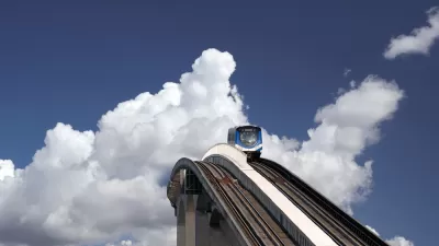
Vancouver shows how to retrofit suburban sprawl with transit and density at a recent Lambda Alpha International event, attended and recounted by development consultant Jim Chappell.
At the September 2017 Land Economics weekend in Vancouver put on by Lambda Alpha International (LAI), Jim Chappell, a former San Francisco Planning and Urban Research Association Executive Director and a development consultant, was impressed enough by to write about it. Like other metropolitan areas that acquired their urban form in the post WWII auto-oriented, the Vancouver metropolitan area had become a sprawling auto-dependent suburbia. However, "Metro Vancouver"—"a federation of 23 jurisdictions"—is well ahead of most other sprawling metropolitan areas in converting into a form that addresses the needs for more equitable and sustainable transit and housing.
The Regional Growth Strategy was updated and adopted by Metro and all 23 jurisdictions in 2012 and extends to 2040. It is a plan for a network of 26 urban nodes ranging in size and character and connected by SkyTrain and other rail connections. There are a planned nine “regional city centers” and 17 smaller regional-scaled activity hubs.
Metro area cities and neighborhoods like Burnaby, Surrey, Brentwood, and Lougheed, are experiencing impressive densification along these SkyTrain transit nodes, with residential buildings up to 600 feet in height. Chappell goes into more detail in the source article.
FULL STORY: How Metropolitan Vancouver Is Reorganizing Suburban Growth Around Transit

Displacement Concerns Grow Along With Residential Developments in Vancouver
In its efforts to build a more environmentally sustainable region by prioritizing transit and transit-oriented development, cities in the Vancouver region also create displacement risks for people who already use and depend on transit.
TOD Around Vancouver's New Rapid Transit, But What Kind?
As a planned rapid transit line gets closer to completion in Vancouver, there's a debate brewing about what sort of development should spring up around it.
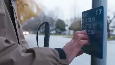
Braille Signage Now at All Vancouver Bus Stops
The city completed installation of signage for people with visual impairments at over 8,000 bus stops.

Alabama: Trump Terminates Settlements for Black Communities Harmed By Raw Sewage
Trump deemed the landmark civil rights agreement “illegal DEI and environmental justice policy.”

Planetizen Federal Action Tracker
A weekly monitor of how Trump’s orders and actions are impacting planners and planning in America.

The 120 Year Old Tiny Home Villages That Sheltered San Francisco’s Earthquake Refugees
More than a century ago, San Francisco mobilized to house thousands of residents displaced by the 1906 earthquake. Could their strategy offer a model for the present?

Indy Neighborhood Group Builds Temporary Multi-Use Path
Community members, aided in part by funding from the city, repurposed a vehicle lane to create a protected bike and pedestrian path for the summer season.

Congestion Pricing Drops Holland Tunnel Delays by 65 Percent
New York City’s contentious tolling program has yielded improved traffic and roughly $100 million in revenue for the MTA.

In Both Crashes and Crime, Public Transportation is Far Safer than Driving
Contrary to popular assumptions, public transportation has far lower crash and crime rates than automobile travel. For safer communities, improve and encourage transit travel.
Urban Design for Planners 1: Software Tools
This six-course series explores essential urban design concepts using open source software and equips planners with the tools they need to participate fully in the urban design process.
Planning for Universal Design
Learn the tools for implementing Universal Design in planning regulations.
Clanton & Associates, Inc.
Jessamine County Fiscal Court
Institute for Housing and Urban Development Studies (IHS)
City of Grandview
Harvard GSD Executive Education
Toledo-Lucas County Plan Commissions
Salt Lake City
NYU Wagner Graduate School of Public Service