


An unsolicited proposal from the engineering firm reimagines a stretch along the L.A. River as a mixed-use mega-development, rich in housing and jobs.
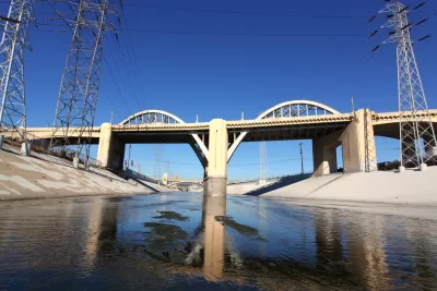
The concrete-lined L.A. River has attracted its share of bold revisions, and AECOM just put forth another one. Antonio Pacheco writes, "The firm's recently-published Los Angeles River Gateway proposal envisions a dense web of newly interconnected neighborhoods and recreational areas surrounding a four-mile stretch of the river."
While it "works within the confines of existing neighborhood plans and leans on already-approved proposals," AECOM's vision is ambitious in scope. "The plan calls for nearly 300 acres of publicly-accessible riparian areas surrounding the river. Those recreational and flood-control areas would be joined, according to the plan, by 36,620 residential units, including at least 7,874 affordable homes."
The plan imagines the area as a mixed-use hub with 150,000 additional jobs and a wide variety of options for pedestrian and transit access. "AECOM proposes a series of approaches for bridging over privately- and publicly-owned rail yards surrounding the river's banks on either side, including plans for underground tunnels that would serve high-speed rail, public transit, and private freight trains," Pacheco writes.
FULL STORY: AECOM wants to add 36,000 housing units around the L.A. River


Downtown Los Angeles on the Rise: A Promising 2025
Fueled by new developments, cultural investments, and a growing dining scene, downtown Los Angeles is poised for significant growth in 2025, despite challenges from recent wildfires and economic uncertainties.
LA Parking Reform is Bearing Fruit
Changes to minimum parking requirements near transit lines are spurring more residential development with little or no on-site parking.

Los Angeles Finalizing Three Long-Awaited Community Plan Updates
Los Angeles is poised to approve a trio of long-planned zoning code updates—for the neighborhoods of Boyle Heights, Downtown, and Hollywood—as the first test cases for a new citywide zoning code update known as re:code LA.

Alabama: Trump Terminates Settlements for Black Communities Harmed By Raw Sewage
Trump deemed the landmark civil rights agreement “illegal DEI and environmental justice policy.”

Planetizen Federal Action Tracker
A weekly monitor of how Trump’s orders and actions are impacting planners and planning in America.

The 120 Year Old Tiny Home Villages That Sheltered San Francisco’s Earthquake Refugees
More than a century ago, San Francisco mobilized to house thousands of residents displaced by the 1906 earthquake. Could their strategy offer a model for the present?

Ken Jennings Launches Transit Web Series
The Jeopardy champ wants you to ride public transit.

BLM To Rescind Public Lands Rule
The change will downgrade conservation, once again putting federal land at risk for mining and other extractive uses.

Indy Neighborhood Group Builds Temporary Multi-Use Path
Community members, aided in part by funding from the city, repurposed a vehicle lane to create a protected bike and pedestrian path for the summer season.
Urban Design for Planners 1: Software Tools
This six-course series explores essential urban design concepts using open source software and equips planners with the tools they need to participate fully in the urban design process.
Planning for Universal Design
Learn the tools for implementing Universal Design in planning regulations.
Clanton & Associates, Inc.
Jessamine County Fiscal Court
Institute for Housing and Urban Development Studies (IHS)
City of Grandview
Harvard GSD Executive Education
Toledo-Lucas County Plan Commissions
Salt Lake City
NYU Wagner Graduate School of Public Service