


The city hopes to accelerate development and mitigate flood risk along the industrial Fort Point Channel with a string of new parks.
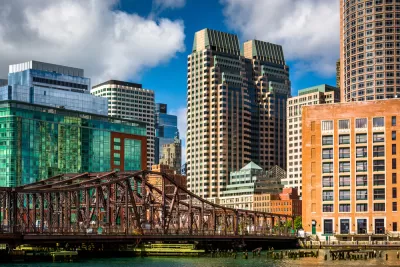
Mayor Martin Walsh and the Trustees of Reservations have released plans for a network of parks along the Fort Point Channel, which they hope will both attract investment to the industrial corridor and mitigate the impacts of sea-level rise on its low-lying neighborhoods.
The channel runs from Boston Harbor to the railyard between South Boston and the South End, and is "one of the hottest pockets in Boston's real estate market," according to the Boston Globe. Conceptual designs call for connecting the parks through pedestrian bridges and artificial islands, bringing a string of green space to an area that is anticipating both major new development—from Amazon and GE—and increasing flood risk.
A recently issued report, “Climate Ready Boston,” identified Fort Point Channel as a throughway that could allow water to inundate low-lying areas of the South End and Roxbury. Shoring it up — by changing the topography, installing water-absorbing marshlands, and giving water someplace to flow safely — could have great benefits.
Those benefits would extend from Fort Point to the downtown area, Chinatown, and South Boston, according to the mayor.
FULL STORY: Park plan envisions fun — and flood control — along Fort Point


Cities Turn to Highway Cap Parks for Economic Development
Some worry that, of the many reasons cities pursue cap parks, creating quality green space is low on the list.
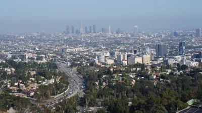
Updating LA’s Tree Rules Could Bring More Shade to Underserved Neighborhoods
A new USC study finds that relaxing Los Angeles’ outdated tree planting guidelines could significantly expand urban tree canopy and reduce shade disparities in lower-income neighborhoods, though infrastructure investments are also needed.
Battery Park Resilience Project Breaks Ground
By 2027, the shoreline will be elevated by 5 feet to prevent flooding from future storm surges.

Study: Maui’s Plan to Convert Vacation Rentals to Long-Term Housing Could Cause Nearly $1 Billion Economic Loss
The plan would reduce visitor accommodation by 25,% resulting in 1,900 jobs lost.

North Texas Transit Leaders Tout Benefits of TOD for Growing Region
At a summit focused on transit-oriented development, policymakers discussed how North Texas’ expanded light rail system can serve as a tool for economic growth.

Why Should We Subsidize Public Transportation?
Many public transit agencies face financial stress due to rising costs, declining fare revenue, and declining subsidies. Transit advocates must provide a strong business case for increasing public transit funding.

How to Make US Trains Faster
Changes to boarding platforms and a switch to electric trains could improve U.S. passenger rail service without the added cost of high-speed rail.

Columbia’s Revitalized ‘Loop’ Is a Hub for Local Entrepreneurs
A focus on small businesses is helping a commercial corridor in Columbia, Missouri thrive.

Invasive Insect Threatens Minnesota’s Ash Forests
The Emerald Ash Borer is a rapidly spreading invasive pest threatening Minnesota’s ash trees, and homeowners are encouraged to plant diverse replacement species, avoid moving ash firewood, and monitor for signs of infestation.
Urban Design for Planners 1: Software Tools
This six-course series explores essential urban design concepts using open source software and equips planners with the tools they need to participate fully in the urban design process.
Planning for Universal Design
Learn the tools for implementing Universal Design in planning regulations.
City of Santa Clarita
Ascent Environmental
Institute for Housing and Urban Development Studies (IHS)
City of Grandview
Harvard GSD Executive Education
Toledo-Lucas County Plan Commissions
Salt Lake City
NYU Wagner Graduate School of Public Service