


Not all property data maps are created equal.

"To aid its neighborhood-level transformation and make its property data truly accessible to practitioners and residents alike, today the City of Pittsburgh unveiled Burgh’s Eye View: Parcels — the latest in its popular series of 'one stop shop' maps for viewing and interacting with the city’s data," according to an article by Robert Burack.
"The Parcels map allows public users to view, by neighborhood, delinquent properties, city-owned properties, and properties in a tax abatement program," adds Burack. "Users can also view information about any specific parcel, including type of owner, property class, sale information, county land value, and liens and tax delinquencies."
Though some of the data was previously included on the city's open data platform, Burgh's Eye View: Parcels includes a couple of new data sets and Burack reports that the new map represents a major upgrade in user experience. The idea that open data platforms are currently limited by difficulties in accessibility and user experience also drove Esri's recent launch of the ArcGIS Hub. For another example of cities moving their open data to a more user-friendly platform, see also Cincinnati's CincyInsights dashboard.
FULL STORY: Visualizing Pittsburgh’s Property Data

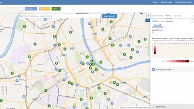
Presenting Municipal Data in an Interactive Map, Nashville Style
The city of Nashville launched the NashView interactive data map earlier this month.

New Interactive Mapping Tool Tracks all of NYC's Infrastructure Projects, Housing Permits, and City Facilities
The New York Department of City Planning has taken its open data practices to a new level with the launch of the Capital Planning Explorer.

Using Artificial Intelligence to Map Telecommuting Prevalence
In the Philadelphia region, residents of wealthier neighborhoods will be more likely to work from home in the future, thus altering travel patterns and transit usage, according to a new mapping project powered by artificial intelligence (AI).

Alabama: Trump Terminates Settlements for Black Communities Harmed By Raw Sewage
Trump deemed the landmark civil rights agreement “illegal DEI and environmental justice policy.”

Study: Maui’s Plan to Convert Vacation Rentals to Long-Term Housing Could Cause Nearly $1 Billion Economic Loss
The plan would reduce visitor accommodation by 25% resulting in 1,900 jobs lost.

Planetizen Federal Action Tracker
A weekly monitor of how Trump’s orders and actions are impacting planners and planning in America.

Waymo Gets Permission to Map SF’s Market Street
If allowed to operate on the traffic-restricted street, Waymo’s autonomous taxis would have a leg up over ride-hailing competitors — and counter the city’s efforts to grow bike and pedestrian on the thoroughfare.

Parklet Symposium Highlights the Success of Shared Spaces
Parklets got a boost during the Covid-19 pandemic, when the concept was translated to outdoor dining programs that offered restaurants a lifeline during the shutdown.

Federal Homelessness Agency Places Entire Staff on Leave
The U.S. Interagency Council on Homelessness is the only federal agency dedicated to preventing and ending homelessness.
Urban Design for Planners 1: Software Tools
This six-course series explores essential urban design concepts using open source software and equips planners with the tools they need to participate fully in the urban design process.
Planning for Universal Design
Learn the tools for implementing Universal Design in planning regulations.
Caltrans
Smith Gee Studio
Institute for Housing and Urban Development Studies (IHS)
City of Grandview
Harvard GSD Executive Education
Toledo-Lucas County Plan Commissions
Salt Lake City
NYU Wagner Graduate School of Public Service