


Florida is infamous for the lack of safety on its roads. A new interactive graphic of the nation's most dangerous highways does nothing to dispel that reputation.
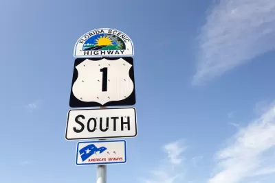
Geotab recently published an interactive graphic that maps out the most dangerous highway in each U.S. state. They calculated a fatal crash rate "based on the annual number of road fatalities and fatal crashes according to the National Highway Traffic Safety Administration, adjusted for the average daily traffic counts provided by the Federal Highway Administration."
The state with the most dangerous highway of all: Florida, where US-1 has a fatal crash rate of 2.8, followed by Texas, where US-83 has a fatal crash rate of 2.0, and California, where I-40 has a fatal crash rate of 1.8. I-40's path of destruction continues into the forth and fifth ranked states, too—Arizona and New Mexico. The state with the safest most dangerous highway: Rhode Island, where I-95 has a fatal crash rate of 0.1.
FULL STORY: The Most Dangerous Highways in America


Let’s End Traffic Stops
The technology to make traffic enforcement obsolete is becoming available. But in the U.S. willing to use it?
Legal Marijuana Still a Challenge for Road Safety
The state of Washington is finding that more and more fatal car crashes involve drivers under the influence of THC. But legal limbo, lack of research, and spotty detection makes the question of what to do very hard to answer.
The Numbers Behind the Country’s Decreasing Traffic Fatalities
Susannah Locke examines some of the data behind the United State’s steady decrease in auto fatalities since a peak in 1969, when 55,043 people died while driving.

What ‘The Brutalist’ Teaches Us About Modern Cities
How architecture and urban landscapes reflect the trauma and dysfunction of the post-war experience.

‘Complete Streets’ Webpage Deleted in Federal Purge
Basic resources and information on building bike lanes and sidewalks, formerly housed on the government’s Complete Streets website, are now gone.
What Trump’s Executive Orders Mean for US Housing Programs
Orders related to DEI and accessibility, among others, may threaten housing programs for those who need them most.

University of Hawai‘i Appoints New Architecture School Dean
The University of Hawai‘i at Mānoa has named Mo Zell as the new dean of its School of Architecture, bringing over two decades of experience in academia, innovative educational programs, and industry partnerships to advance design education.

Part of San Francisco Waterfront Highway to Become Pedestrian-Only in April
Two miles of the ‘Great Highway’ will be permanently closed to cars, in part due to erosion that makes the road unsafe for vehicles.

El Paso Wastewater Purification Facility Breaks Ground
As water supplies become strained and technology advances, cities look to wastewater as a viable source of drinking water.
Urban Design for Planners 1: Software Tools
This six-course series explores essential urban design concepts using open source software and equips planners with the tools they need to participate fully in the urban design process.
Planning for Universal Design
Learn the tools for implementing Universal Design in planning regulations.
North Jersey Transportation Planning Authority (NJTPA)
Economic & Planning Systems, Inc.
UCLA Lewis Center for Regional Policy Studies
Mpact (formerly Rail~Volution)
Chaddick Institute at DePaul University
City of Piedmont, CA
Great Falls Development Authority, Inc.
HUDs Office of Policy Development and Research