


Just in time for United Nations World Wildlife Day, a new initiative in Israel has launched to identify deadly road crossings for animals by harnessing data collected from the Waze app.
Waze and the Society for the Protection of Nature in Israel (SPNI) have partnered in support of wildlife by using the Waze app's roadkill button to identify areas where animal deaths are occurring at higher rates. Sharon Udasin of The Jerusalem Post reports that the data collected will help to identify areas where wildlife are threatened by vehicles and give SPNI an opportunity to create solutions for their safe movement.
Shmulik Yidov, head of SPNI's Mammal Center, notes that in addition to reducing the number of animal deaths, they are trying to solve the problems created by roadways that fragment animal populations, "creating demographic and genetic diversity problems in the long-term."
With the data generated, the organization will be creating a "Red Road Atlas for Wildlife" and taking action to regulate safe crosswalks for animals. Through both observation and the use of surveillance cameras in problematic areas, SPNI representatives said they hope to deepen their understanding as to why these animals are being run over and what steps can be taken to minimize the number of deaths.
FULL STORY: Waze and SPNI team up to prevent wildlife from becoming roadkill

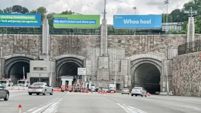
Waze Outfits NYC Tunnels with Beacons for Underground Navigation
The tech is part of a public-private partnership meant to improve connectivity to Waze and other navigation apps from underground.
Cities Seeking New Weapons in the Battle Against Waze-Induced Traffic
Los Altos, California has erected a new roadblock in its ongoing effort to keep drivers from cutting through residential neighborhoods, beckoned by the popular navigation app Waze.

There's No App for Silver Bullets
Two planning researchers, one a professor at Tufts and another independent, make the case against apps as a panacea for urban problems.

Alabama: Trump Terminates Settlements for Black Communities Harmed By Raw Sewage
Trump deemed the landmark civil rights agreement “illegal DEI and environmental justice policy.”

Planetizen Federal Action Tracker
A weekly monitor of how Trump’s orders and actions are impacting planners and planning in America.

The 120 Year Old Tiny Home Villages That Sheltered San Francisco’s Earthquake Refugees
More than a century ago, San Francisco mobilized to house thousands of residents displaced by the 1906 earthquake. Could their strategy offer a model for the present?

In Both Crashes and Crime, Public Transportation is Far Safer than Driving
Contrary to popular assumptions, public transportation has far lower crash and crime rates than automobile travel. For safer communities, improve and encourage transit travel.

Report: Zoning Reforms Should Complement Nashville’s Ambitious Transit Plan
Without reform, restrictive zoning codes will limit the impact of the city’s planned transit expansion and could exclude some of the residents who depend on transit the most.

Judge Orders Release of Frozen IRA, IIJA Funding
The decision is a victory for environmental groups who charged that freezing funds for critical infrastructure and disaster response programs caused “real and irreparable harm” to communities.
Urban Design for Planners 1: Software Tools
This six-course series explores essential urban design concepts using open source software and equips planners with the tools they need to participate fully in the urban design process.
Planning for Universal Design
Learn the tools for implementing Universal Design in planning regulations.
Clanton & Associates, Inc.
Jessamine County Fiscal Court
Institute for Housing and Urban Development Studies (IHS)
City of Grandview
Harvard GSD Executive Education
Toledo-Lucas County Plan Commissions
Salt Lake City
NYU Wagner Graduate School of Public Service