


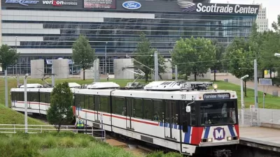
The city of St. Louis is taking the first official steps toward the ambitious Northside-Southside MetroLink proposal.
Leah Thorsen reports on the early efforts to evaluate a proposed Northside-Southside MetroLink route in St. Louis.
Early into the study, according to Thorsen, "a main focus is learning what has changed since the route last was examined in 2008" while looking for ways to "connect to the $1.75 billion National Geospatial-Intelligence Agency headquarters set to be built just northwest of downtown…"
Thorsen quotes Dan Meyers, a project manager with AECOM, which is leading the consulting team for the study, to explain the initial steps of the study. One early benchmark to look for is a community engagement plan—expected to be implemented as early as April or May.
Thorsen also describes the current, speculative vision for the project: "A 31-mile route from north St. Louis County through the city and into south St. Louis…with a pricetag estimated at $2.2 billion."
Planetizen last checked in with the Northside-Southside project in June 2016, when the long-serving mayor of the city, Francis Slay, expressed strong support for the project.
FULL STORY: MetroLink study to focus on justifying project, showing strong local financial commitment

With Mayoral Support—What's Next for Proposed MetroLink Extension in St. Louis
The long-time mayor of St. Louis has announced his top priority for his final year in office, and it's good news for transit advocates.
Crime, Cheap Gas, Declining Population: A Cocktail for Decreased Transit Ridership
St. Louis transit planners are evaluating the reasons behind a decline in transit use as the Metro Transit system prepares its first light expansion in years.

State Leaders Warn of Risks to Southern California Rail Corridor
Coastal erosion and rising sea levels threaten one of the nation’s most scenic—and strategically important—rail corridors.

Trump Administration Could Effectively End Housing Voucher Program
Federal officials are eyeing major cuts to the Section 8 program that helps millions of low-income households pay rent.

Planetizen Federal Action Tracker
A weekly monitor of how Trump’s orders and actions are impacting planners and planning in America.

Ken Jennings Launches Transit Web Series
The Jeopardy champ wants you to ride public transit.

Rebuilding Smarter: How LA County Is Guiding Fire-Ravaged Communities Toward Resilience
Los Angeles County is leading a coordinated effort to help fire-impacted communities rebuild with resilience by providing recovery resources, promoting fire-wise design, and aligning reconstruction with broader sustainability and climate goals.

When Borders Blur: Regional Collaboration in Action
As regional challenges outgrow city boundaries, “When Borders Blur” explores how cross-jurisdictional collaboration can drive smarter, more resilient urban planning, sharing real-world lessons from thriving partnerships across North America.

Philadelphia Is Expanding its Network of Roundabouts
Roundabouts are widely shown to decrease traffic speed, reduce congestion, and improve efficiency.
Urban Design for Planners 1: Software Tools
This six-course series explores essential urban design concepts using open source software and equips planners with the tools they need to participate fully in the urban design process.
Planning for Universal Design
Learn the tools for implementing Universal Design in planning regulations.
Ada County Highway District
Clanton & Associates, Inc.
Jessamine County Fiscal Court
Institute for Housing and Urban Development Studies (IHS)
City of Grandview
Harvard GSD Executive Education
Toledo-Lucas County Plan Commissions
Salt Lake City
NYU Wagner Graduate School of Public Service