


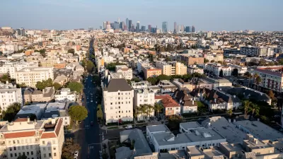
New data shows that the city of Los Angeles owns nearly 9,000 parcels throughout the region—and that it could be doing a lot more with them.

For the first time in a decade, the city of Los Angeles has a comprehensive catalog of its own real-estate portfolio, and it comes in the form of an interactive, searchable map.
Controller Ron Galperin—a former real-estate attorney—published PropertyPanel.LA along with a memo urging city leaders to realize the transformative potential of its nearly 9,000 parcels.
"The real-estate assets of the city are vast, and they could be delivering a tremendous amount of value to the residents, the businesses, and the taxpayers of LA," he told The Planning Report. "It’s long overdue that that happens."
In fact, the memo suggests the creation of a new position—Chief Asset Manager—with the authority to undertake construction, sales, leases, development, joint ventures, and "all the aspects of real-estate management."
"It should be someone with a good amount of private-sector experience, because the mindset it requires is not just about doing RFPs and RFQs," Galperin says. "It’s about doing deals."
The report notes that previous accounts of municipal assets were "incomplete, inadequate, outdated, and in some cases incorrect." Galperin tells The Planning Report that putting the new data into an easily accessible map "helps to turn everybody into partners in holding the city accountable."
After all, he says, publicly owned property should be used in the service of the public—as parkland, as housing for the homeless, or indirectly, as a source of municipal revenue.
Fulfilling that ideal will require some long-term planning, and it's time to get started, Galperin says:
I don’t believe in selling, leasing, or joint-venturing property just to close a budget gap in a particular year. We have to meet strict standards about the value that the deal will deliver over the long term. Plus, we want to get input from a lot of different stakeholders about the best thing to do with particular properties.
But here’s the thing: The city owns so many properties that even if we did only a somewhat better job with just some of them, we’d be well ahead of where we are now.
FULL STORY: LA Controller Galperin Makes Transparent LA City’s "Underutilized" Properties

Simplifying Transit-Adjacent Real Estate Development
In a talk delivered at last December’s US High Speed Rail Conference in Los Angeles, Allan Kotin of Allan D. Kotin and Associates outlined the short-term decisions that can lead to long-term returns on transit-oriented development.
How L.A. Failed to Stop Landlords From Turning Low-Cost Housing Into Tourist Hotels
Fifteen years ago, Los Angeles passed a law to preserve residential hotels as housing of last resort. Now, amid the homelessness crisis, Capital & Main and ProPublica found some hotels may be violating that law by offering rooms to tourists.

Million-Dollar Homes Becoming Standard Fare Across Los Angeles
As households with means seek to escape crowded apartment buildings and take advantage of historically low mortgage rates, average home prices of over $1 million are proliferating across the LA region.

Alabama: Trump Terminates Settlements for Black Communities Harmed By Raw Sewage
Trump deemed the landmark civil rights agreement “illegal DEI and environmental justice policy.”

Planetizen Federal Action Tracker
A weekly monitor of how Trump’s orders and actions are impacting planners and planning in America.

The 120 Year Old Tiny Home Villages That Sheltered San Francisco’s Earthquake Refugees
More than a century ago, San Francisco mobilized to house thousands of residents displaced by the 1906 earthquake. Could their strategy offer a model for the present?

Ken Jennings Launches Transit Web Series
The Jeopardy champ wants you to ride public transit.

BLM To Rescind Public Lands Rule
The change will downgrade conservation, once again putting federal land at risk for mining and other extractive uses.

Indy Neighborhood Group Builds Temporary Multi-Use Path
Community members, aided in part by funding from the city, repurposed a vehicle lane to create a protected bike and pedestrian path for the summer season.
Urban Design for Planners 1: Software Tools
This six-course series explores essential urban design concepts using open source software and equips planners with the tools they need to participate fully in the urban design process.
Planning for Universal Design
Learn the tools for implementing Universal Design in planning regulations.
Clanton & Associates, Inc.
Jessamine County Fiscal Court
Institute for Housing and Urban Development Studies (IHS)
City of Grandview
Harvard GSD Executive Education
Toledo-Lucas County Plan Commissions
Salt Lake City
NYU Wagner Graduate School of Public Service