


Los Angeles County has inventoried their trees and devised a strategy for fostering an urban canopy. Park planner Clement Lau explains.
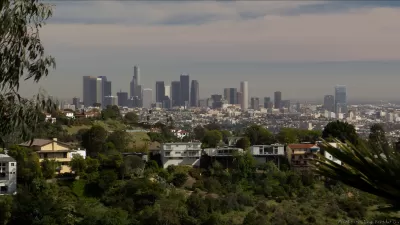
An urban forest is the collection of trees, plants, and vegetation found along a city’s streets, within parks, and in the built environment. Urban forest are increasingly recognized as important for a variety of functions including sequestering green house gases, filtering airborne pollutants, moderating urban temperatures—including the "heat island" effect, reducing stormwater runoff, increasing walkability, and even improving the psychological and social environment of cities.
Los Angeles County, went beyond the
. . . traditional scope of work and the boundaries of existing parks by including analyses and recommendations on urban greening and urban forestry community-wide. While we certainly wanted to increase the number and acreage of parks in these communities, we also realized that: 1) the opportunities to do so are limited given the scarcity of available land and funding; and 2) our end goal is to improve the quality of life for residents, not just to create parks. To accomplish this goal, we needed to look at the communities in their entirety and seek to make all the neighborhoods (not just the parks) greener, more attractive, more shaded, more walkable, and safer.
The County Parks Department first needed to what it already had so it
. . . applied for and received a CalFIRE grant to complete a tree inventory in all of the existing parks in the communities. Data from the inventory was used to create a database within a tool called iTrees Streets, which is a street tree management and analysis tool that uses tree inventory data to assign dollar values to energy savings, carbon monoxide reduction, air quality improvements, stormwater control, and property value increase. The tool is free and was developed by a team of researchers from the U.S. Department of Agriculture (USDA) Forest Service, Davey Tree Service, and the International Society of Arboriculture (ISA). Each of the Community Parks and Recreation Plans contains the following information about trees in County parks: species composition, age composition, estimated benefits provided by the trees in dollar value, the general condition of the trees, necessary maintenance, and potential conflicts with existing infrastructure.
The county then made this information available in its outreach efforts in the development of Community Parks and Recreation Plans for six communities identified as park poor:
Each plan contains a section addressing the urban forest, and includes strategies for enhancing the urban forest not only in the parks, but along key corridors, as part of pocket forests, and on freeway buffer sites. Although many residents were excited about the aesthetic and environmental benefits of new trees, some were also concerned about public safety and how the introduction of new trees might limit views and provide hiding spaces for illicit activity. The plans took into consideration these concerns by helping residents pick trees that would provide environmental benefits, while acknowledging public safety concerns and recommending trees with high branching patterns, minimal leaf litter, and faster growth rates. Conversations with community members and recommendations of the plans make these communities poised and ready for the expansion of their urban forests.
For more about L.A. County's urban forestry program, please see the source article.
FULL STORY: Seeing the Forest for the Trees: Planning for Parks and Urban Forests in Los Angeles County

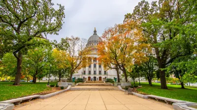
How Madison’s Tree Planting Efforts Are Growing a Healthier Community
Madison’s annual tree planting initiative is enhancing environmental resilience, public health, and community livability by adding 1,400 carefully selected trees citywide, with strong community and institutional support for urban forestry.
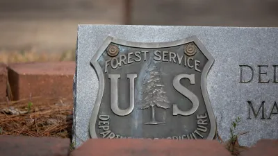
What Forest Service Cuts Mean for Cities
U.S. Forest Service employees work on projects that have impacts far beyond remote, rural wilderness areas.
A Plan to Expand Tree Canopy Across Dayton
Dayton is developing an urban forest master plan, using a $2 million grant to expand its tree canopy, address decades of tree loss, and enhance environmental equity across the city.

Alabama: Trump Terminates Settlements for Black Communities Harmed By Raw Sewage
Trump deemed the landmark civil rights agreement “illegal DEI and environmental justice policy.”

Planetizen Federal Action Tracker
A weekly monitor of how Trump’s orders and actions are impacting planners and planning in America.

The 120 Year Old Tiny Home Villages That Sheltered San Francisco’s Earthquake Refugees
More than a century ago, San Francisco mobilized to house thousands of residents displaced by the 1906 earthquake. Could their strategy offer a model for the present?

Ken Jennings Launches Transit Web Series
The Jeopardy champ wants you to ride public transit.

BLM To Rescind Public Lands Rule
The change will downgrade conservation, once again putting federal land at risk for mining and other extractive uses.

Indy Neighborhood Group Builds Temporary Multi-Use Path
Community members, aided in part by funding from the city, repurposed a vehicle lane to create a protected bike and pedestrian path for the summer season.
Urban Design for Planners 1: Software Tools
This six-course series explores essential urban design concepts using open source software and equips planners with the tools they need to participate fully in the urban design process.
Planning for Universal Design
Learn the tools for implementing Universal Design in planning regulations.
Clanton & Associates, Inc.
Jessamine County Fiscal Court
Institute for Housing and Urban Development Studies (IHS)
City of Grandview
Harvard GSD Executive Education
Toledo-Lucas County Plan Commissions
Salt Lake City
NYU Wagner Graduate School of Public Service