


A blog post exploring why Los Angeles is more car-dependent than some less dense cities.

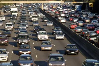
Last week, I visited Los Angeles. Even before visiting, I was most curious about one question: why is Los Angeles dense and car-oriented at the same time? Los Angeles has just over 8,000 people per square mile—not as much as the most transit-oriented cities, but more than many cities that are less car-oriented, such as the larger cities of the Pacific Northwest and the Rust Belt.
For example, Los Angeles is slightly more dense than Seattle (which has just over 7,000 people per square mile). Yet one-third of Seattle residents bike, walk, or take transit to work, more than twice as many as in Los Angeles (15.5%). Pittsburgh has about 5,500 people per square mile and Portland even fewer, yet in both cities about one-quarter of commuters bike, walk or take transit—still more than Los Angeles. More broadly, the relationship between non-automotive commuting and density is strongest at the extremes: the six cities with the largest non-automotive mode shares have about or more than 10,000 people per square mile, and the ten most car-dominated cities all have under 4,000 people per square mile. But mid-density cities vary a bit more.(1) Why?
From riding around Los Angeles's buses and trains and seeing dozens of neighborhoods(2), I of course have no definitive answer. But I do have a couple of mildly-educated guesses.
First of all, street design is a logical suspect. Most of the commercial streets I saw were six lanes wide; by contrast, commercial streets in New York City are often only four lanes wide, and two of those lanes are commonly used for on-street parking (which means that from a pedestrian's perspective, these streets effectively have two lanes). Even though Los Angeles also seems to allow on-street parking on many commercial streets, my sense was that on-street parking lanes were used less heavily in Los Angeles, so that in Los Angeles a six-lane street really is six lanes.(3) Six-lane streets are not much fun to cross, so people choose not to walk on them.
One extreme example is on Wilshire Boulevard just east of Westwood (say, around the 10700 block if you want to see it on Street View). This is a block full of high-rise condos: the perfect spot for pedestrian-oriented development. Yet this stretch of Wilshire is eight lanes wide, without even a median to break up a pedestrian's street-crossing adventure.
Los Angeles's wide streets may also explain the historic weakness of Los Angeles’s downtown. Nearly every American downtown is ringed by expressways that facilitate commuting from suburbia—but downtown Los Angeles has some six-lane speedways that are no fun to cross, but that facilitate commutes from more suburban parts of the city.
Second, the sheer size of Los Angeles may be relevant. A city with the density of Los Angeles and only half a million people would encompass about 60 square miles—the size of the District of Columbia. In such a city, no neighborhood is more than about six or seven miles from downtown, and so public transit is a reasonable option almost anywhere within the city limits.
By contrast, in an equally dense city the size of Los Angeles, transit takes much longer. For example, the Sylmar neighborhood, at the city’s northern extremity, is more than 20 miles from City Hall and an hour away by rail and bus—so I am guessing a bus-alone commute would take over two hours. In other words, because of Los Angeles's sheer size, perhaps it needed a truly world-class public transit system to have the transit more share of a Pittsburgh or a Seattle.
Any other thoughts, dear readers?
(1) Mode share data is at http://iqc.ou.edu/2013/10/22/the-latest-bike-walk-and-transit-usage-data/ and density data is at http://www.governing.com/gov-data/population-density-land-area-cities-map.html.
(2) Pictures of each neighborhood are available at my Facebook page; I have about two dozen Los Angeles photo albums.
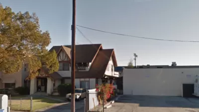
(3) Assuming I'm right about the on-street parking, why would Angelenos be less eager to park on the street than New Yorkers? Much of Los Angeles was built after minimum parking requirements became common, which in turn might mean that more buildings have off-street parking, so in many areas on-street parking is not so congested as in other cities.

How One L.A. Developer Uses the Law to Build Apartments
California’s density bonus law lets developers skirt some zoning regulations to build multifamily housing.
Opinion: Los Angeles Must Prioritize Bikes and Buses
L.A. has a plan for improving mobility. Why are city leaders ignoring it?
Study: More Bike Infrastructure Could Prevent 15,000 Deaths Annually
In addition to reducing air pollution and congestion, improving bike infrastructure could save thousands of lives each year, according to new research.

Study: Maui’s Plan to Convert Vacation Rentals to Long-Term Housing Could Cause Nearly $1 Billion Economic Loss
The plan would reduce visitor accommodation by 25,% resulting in 1,900 jobs lost.

North Texas Transit Leaders Tout Benefits of TOD for Growing Region
At a summit focused on transit-oriented development, policymakers discussed how North Texas’ expanded light rail system can serve as a tool for economic growth.

Why Should We Subsidize Public Transportation?
Many public transit agencies face financial stress due to rising costs, declining fare revenue, and declining subsidies. Transit advocates must provide a strong business case for increasing public transit funding.

How to Make US Trains Faster
Changes to boarding platforms and a switch to electric trains could improve U.S. passenger rail service without the added cost of high-speed rail.

Columbia’s Revitalized ‘Loop’ Is a Hub for Local Entrepreneurs
A focus on small businesses is helping a commercial corridor in Columbia, Missouri thrive.

Invasive Insect Threatens Minnesota’s Ash Forests
The Emerald Ash Borer is a rapidly spreading invasive pest threatening Minnesota’s ash trees, and homeowners are encouraged to plant diverse replacement species, avoid moving ash firewood, and monitor for signs of infestation.
Urban Design for Planners 1: Software Tools
This six-course series explores essential urban design concepts using open source software and equips planners with the tools they need to participate fully in the urban design process.
Planning for Universal Design
Learn the tools for implementing Universal Design in planning regulations.
City of Santa Clarita
Ascent Environmental
Institute for Housing and Urban Development Studies (IHS)
City of Grandview
Harvard GSD Executive Education
Toledo-Lucas County Plan Commissions
Salt Lake City
NYU Wagner Graduate School of Public Service