


The University of Texas Arlington's Institute of Urban Studies is doing to legwork for an update of the Downtown Dallas 360 master plan.
A team of researchers and doctoral students from the University of Texas at Arlington's Institute of Urban Studies "are embarking on a first-of-its-kind study on the walkability of downtown Dallas," according to an article by Brandon Formby.
Formby sets the stage for the research, which takes place in a "downtown whose activity once withered at the end of the workday is now peppered with burgeoning hot spots of residential, recreational and retail vitality."
Hoping to account for the elements already contributing to the success of Downtown Dallas, "[collecting] data to identify and map which city blocks have the highest concentration of pedestrians, the safest crosswalks and the most well-maintained sidewalks."
"In all, the team will collect data on about 30 different urban design features for each street segment," adds Formby. The article provides context for the study in the form of the growing body of literature on the importance of walkability to a number of desirable outcomes. Formby also drills down into specifics of urban design, such as shade trees.
FULL STORY: Counting trees? Downtown Dallas taking steps to be more pedestrian friendly


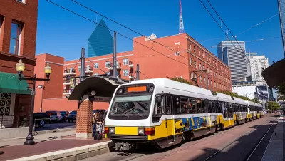
North Texas Transit Leaders Tout Benefits of TOD for Growing Region
At a summit focused on transit-oriented development, policymakers discussed how North Texas’ expanded light rail system can serve as a tool for economic growth.

Dallas Considers Nixing Parking Requirements
According to one local official, Dallas projects routinely build 20 to 30 percent more parking than they need, driving up the cost of housing and leading to unsustainable land use patterns.

Dallas Extends Permit for Downtown Drive-Thru
The city has indicated this is the last time it will extend a permit for a drive-thru at a McDonald’s restaurant as it transitions to supporting a denser, more walkable downtown environment.

Alabama: Trump Terminates Settlements for Black Communities Harmed By Raw Sewage
Trump deemed the landmark civil rights agreement “illegal DEI and environmental justice policy.”

Planetizen Federal Action Tracker
A weekly monitor of how Trump’s orders and actions are impacting planners and planning in America.

The 120 Year Old Tiny Home Villages That Sheltered San Francisco’s Earthquake Refugees
More than a century ago, San Francisco mobilized to house thousands of residents displaced by the 1906 earthquake. Could their strategy offer a model for the present?

Ken Jennings Launches Transit Web Series
The Jeopardy champ wants you to ride public transit.

BLM To Rescind Public Lands Rule
The change will downgrade conservation, once again putting federal land at risk for mining and other extractive uses.

Indy Neighborhood Group Builds Temporary Multi-Use Path
Community members, aided in part by funding from the city, repurposed a vehicle lane to create a protected bike and pedestrian path for the summer season.
Urban Design for Planners 1: Software Tools
This six-course series explores essential urban design concepts using open source software and equips planners with the tools they need to participate fully in the urban design process.
Planning for Universal Design
Learn the tools for implementing Universal Design in planning regulations.
Clanton & Associates, Inc.
Jessamine County Fiscal Court
Institute for Housing and Urban Development Studies (IHS)
City of Grandview
Harvard GSD Executive Education
Toledo-Lucas County Plan Commissions
Salt Lake City
NYU Wagner Graduate School of Public Service