


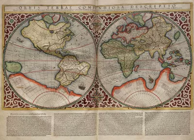
Typical world maps badly misrepresent the size of countries; a new web app shows their true scale.
The True Size Of is an interactive app that seeks to improve our skewed sense of global geography by correcting the world map.
The web app allows users to drag a country to another part of the map. The country's size and shape will change until it compares accurately to its new location.
For a little background on why "the world's most ubiquitous map" is so distorted, Liz Stinson at Wired explains:
The Mercator projection is an inherently flawed design. It exaggerates the size of countries closest to the poles while depicting size most faithfully at the equator. Though it was once a handy navigational tool for sailors, the map has instilled in the rest of us a gross misunderstanding of geography and relative country size.
FULL STORY: Fascinating App Shows You How Misleading Maps Can Be

Mapped: Every Building in the United States
Using data from Microsoft, the New York Times has published an online map showing the placement of every building in the country, in a simple black and white format.
The Importance of Geographic Literacy
Maps are still an important tool in teaching kids to be global citizens.
Putting Alternative Fuel Stations on the Map
Yesterday, the U.S. Department of Energy released an interactive map displaying thousands of alternative fuel stations around the nation.

Alabama: Trump Terminates Settlements for Black Communities Harmed By Raw Sewage
Trump deemed the landmark civil rights agreement “illegal DEI and environmental justice policy.”

Study: Maui’s Plan to Convert Vacation Rentals to Long-Term Housing Could Cause Nearly $1 Billion Economic Loss
The plan would reduce visitor accommodation by 25% resulting in 1,900 jobs lost.

Planetizen Federal Action Tracker
A weekly monitor of how Trump’s orders and actions are impacting planners and planning in America.

Wind Energy on the Rise Despite Federal Policy Reversal
The Trump administration is revoking federal support for renewable energy, but demand for new projects continues unabated.

Passengers Flock to Caltrain After Electrification
The new electric trains are running faster and more reliably, leading to strong ridership growth on the Bay Area rail system.

Texas Churches Rally Behind ‘Yes in God’s Back Yard’ Legislation
Religious leaders want the state to reduce zoning regulations to streamline leasing church-owned land to housing developers.
Urban Design for Planners 1: Software Tools
This six-course series explores essential urban design concepts using open source software and equips planners with the tools they need to participate fully in the urban design process.
Planning for Universal Design
Learn the tools for implementing Universal Design in planning regulations.
Caltrans
Smith Gee Studio
Institute for Housing and Urban Development Studies (IHS)
City of Grandview
Harvard GSD Executive Education
Toledo-Lucas County Plan Commissions
Salt Lake City
NYU Wagner Graduate School of Public Service