


Part of a $380 million renovation project on the Gateway Arch grounds, a new riverfront path is built two feet higher above the banks of the mighty Mississippi River.
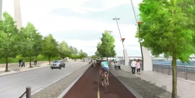
"The stretch of riverfront below the Gateway Arch should better withstand flooding after being raised about two feet, meaning fewer shutdowns when the Mississippi River rises in the area popular with tourists," reports Leah Thorsen.
The riverfront project is part of a $380 million restoration of the Gateway Arch grounds, including the rebuilt Leonor K. Sullivan Boulevard and a bike path along a 1.5-mile stretch from Chouteau Avenue to Biddle Street. "Other upgrades include new lighting, landscaping, benches and bike racks," adds Thorsen. Planetizen has been tracking the CityArchRiver project, as it's called, since its early conceptual stages in September 2010.
The flood control aspects of the project weigh prominently, however, as the city prepares to celebrate the opening of the new path today. Just this previous winter, the city of St. Louis saw widespread flooding, and construction of the Gateway Arch renovation project was shut down three times by flooding since construction commenced in December 2013. The rest of Gateway Arch grounds are expected to reopen this fall.
FULL STORY: Rebuilt and elevated Arch riverfront should mean less flooding

Five Plans for Reviving the St. Louis Gateway Arch Park
Five finalists have been announced in a design competition to rethink the park near St. Louis' iconic Gateway Arch. Fast Co. Design takes a look at the contenders.
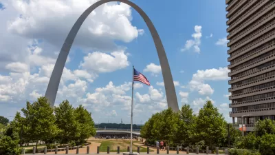
Newly Minted St. Louis Gateway Arch National Park Reviewed
The recently revitalized and designated as a National Park St. Louis Gateway Arch National Park is described by park planner Clement Lau.

Design Review: Revamped Gateway Arch an Urban Success
Pulitzer Prize-winning critic Blair Kamin assesses the remodeled Gateway Arch in St. Louis, prior to its big public opening on July 3.

Alabama: Trump Terminates Settlements for Black Communities Harmed By Raw Sewage
Trump deemed the landmark civil rights agreement “illegal DEI and environmental justice policy.”

Planetizen Federal Action Tracker
A weekly monitor of how Trump’s orders and actions are impacting planners and planning in America.

The 120 Year Old Tiny Home Villages That Sheltered San Francisco’s Earthquake Refugees
More than a century ago, San Francisco mobilized to house thousands of residents displaced by the 1906 earthquake. Could their strategy offer a model for the present?

Ken Jennings Launches Transit Web Series
The Jeopardy champ wants you to ride public transit.

BLM To Rescind Public Lands Rule
The change will downgrade conservation, once again putting federal land at risk for mining and other extractive uses.

Indy Neighborhood Group Builds Temporary Multi-Use Path
Community members, aided in part by funding from the city, repurposed a vehicle lane to create a protected bike and pedestrian path for the summer season.
Urban Design for Planners 1: Software Tools
This six-course series explores essential urban design concepts using open source software and equips planners with the tools they need to participate fully in the urban design process.
Planning for Universal Design
Learn the tools for implementing Universal Design in planning regulations.
Clanton & Associates, Inc.
Jessamine County Fiscal Court
Institute for Housing and Urban Development Studies (IHS)
City of Grandview
Harvard GSD Executive Education
Toledo-Lucas County Plan Commissions
Salt Lake City
NYU Wagner Graduate School of Public Service