


With the controversy about the value of its newly opened streetcar ongoing, Washington, D.C. has commenced with a planning process for extending the line to Georgetown.
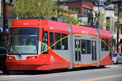
David Alpert provides a sneak peak into the proposed plans for the DC streetcar extension. According to Alpert, "planners from the District Department of Transportation (DDOT) [presented] options to extend the existing H Street streetcar route to Georgetown" this week. In addition to a no-build option, the current plan includes two potential configurations: "one in a dedicated lane from Mount Vernon Square to Washington Circle but in mixed traffic the rest of the way, and a new option to use dedicated lanes for almost the whole length." After opening in February 2016, the D.C. streetcar has been one of the prime talking points in discussions about the value of transit planned to share lane space with automobiles.
The dedicated lane is the result of community feedback, according to Alpert: "more and more people argued that without dedicated lanes, the streetcar would not offer a faster ride, making it no more appealing, transportation-wise, than existing bus lines." The article is also but one in a series that Greater Greater Washington calls a "streetcar mega-feature."
FULL STORY: DC's streetcar may go to Georgetown with dedicated lanes

D.C. Streetcar Began Service Saturday (Seriously!)
Yes, this is the real deal. After years of delay and planning and construction mishaps, the long-awaited $200 million, 2.2 mile line streetcar line down H Street began service Saturday. Not all media were kind to the streetcar, even on opening day.
Report: Construction, Management Problems Plague the D.C. Streetcar
The long-delayed D.C. Streetcar got some very bad news last week, when a panel of industry experts found evidence of construction mistakes that will severely impact the system's reliability.
D.C. Officials Dramatically Scale Back Streetcar System
In a recent move, officials from Mayor Vincent C. Gray's administration shortened DC's streetcar system to a much-shorter eight miles.

Trump Administration Could Effectively End Housing Voucher Program
Federal officials are eyeing major cuts to the Section 8 program that helps millions of low-income households pay rent.

Planetizen Federal Action Tracker
A weekly monitor of how Trump’s orders and actions are impacting planners and planning in America.

Ken Jennings Launches Transit Web Series
The Jeopardy champ wants you to ride public transit.

Rebuilding Smarter: How LA County Is Guiding Fire-Ravaged Communities Toward Resilience
Los Angeles County is leading a coordinated effort to help fire-impacted communities rebuild with resilience by providing recovery resources, promoting fire-wise design, and aligning reconstruction with broader sustainability and climate goals.

When Borders Blur: Regional Collaboration in Action
As regional challenges outgrow city boundaries, “When Borders Blur” explores how cross-jurisdictional collaboration can drive smarter, more resilient urban planning, sharing real-world lessons from thriving partnerships across North America.

Philadelphia Is Expanding its Network of Roundabouts
Roundabouts are widely shown to decrease traffic speed, reduce congestion, and improve efficiency.
Urban Design for Planners 1: Software Tools
This six-course series explores essential urban design concepts using open source software and equips planners with the tools they need to participate fully in the urban design process.
Planning for Universal Design
Learn the tools for implementing Universal Design in planning regulations.
Ada County Highway District
Clanton & Associates, Inc.
Jessamine County Fiscal Court
Institute for Housing and Urban Development Studies (IHS)
City of Grandview
Harvard GSD Executive Education
Toledo-Lucas County Plan Commissions
Salt Lake City
NYU Wagner Graduate School of Public Service