


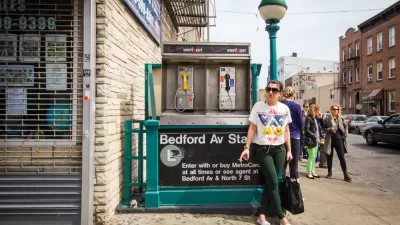
A fun, if not conclusive, exercise in layering the country's most famous transit map with data from the real estate market.

"You can pay up to $845 less per month by adding one extra subway stop and 2 minutes more to your daily commute," reports Nicole Levy.
That information comes via a new study by the apartment rental listings website RentHop, which warrants caution, given how much data is missing from RentHop's portrayal of the city's rental market.
RentHop's data does, however, reveal interesting patterns of rental disparity of along transit lines. Levy shares the headlines:
…the city's most expensive one-bedroom rentals can be found near the 23rd Street station on the 1 line, where the median price is $4,000 a month.
The most affordable are in the Bronx on the 5 and 6 lines, where the median is $1,250 near the Gun Hill Road and Pelham Bay Park stations.
All of RentHop's findings are laid out in an infographic that could distract the attention of those interested in real estate and transit for hours.
FULL STORY: See Which Subway Station Is Closest to the Cheapest Apartments

Report: L Train Closure Finally Impacting the Brooklyn Real Estate Market
The New York MTA is planning to shut down the L Train from Brooklyn to Manhattan in 2019, and renters in the area no longer find the area along the route as attractive.

Rents Falling at the Upper End of New York's Real Estate Market
The construction of thousands of rental apartments in Manhattan, Brooklyn, and Queens are credited with driving down costs at the upper end of the New York City rental market.
New York Subway Reaches One Billion Ride Milestone
The system’s 2024 performance is on track for its fastest growth since the pandemic.

Alabama: Trump Terminates Settlements for Black Communities Harmed By Raw Sewage
Trump deemed the landmark civil rights agreement “illegal DEI and environmental justice policy.”

Planetizen Federal Action Tracker
A weekly monitor of how Trump’s orders and actions are impacting planners and planning in America.

The 120 Year Old Tiny Home Villages That Sheltered San Francisco’s Earthquake Refugees
More than a century ago, San Francisco mobilized to house thousands of residents displaced by the 1906 earthquake. Could their strategy offer a model for the present?

In Both Crashes and Crime, Public Transportation is Far Safer than Driving
Contrary to popular assumptions, public transportation has far lower crash and crime rates than automobile travel. For safer communities, improve and encourage transit travel.

Report: Zoning Reforms Should Complement Nashville’s Ambitious Transit Plan
Without reform, restrictive zoning codes will limit the impact of the city’s planned transit expansion and could exclude some of the residents who depend on transit the most.

Judge Orders Release of Frozen IRA, IIJA Funding
The decision is a victory for environmental groups who charged that freezing funds for critical infrastructure and disaster response programs caused “real and irreparable harm” to communities.
Urban Design for Planners 1: Software Tools
This six-course series explores essential urban design concepts using open source software and equips planners with the tools they need to participate fully in the urban design process.
Planning for Universal Design
Learn the tools for implementing Universal Design in planning regulations.
Clanton & Associates, Inc.
Jessamine County Fiscal Court
Institute for Housing and Urban Development Studies (IHS)
City of Grandview
Harvard GSD Executive Education
Toledo-Lucas County Plan Commissions
Salt Lake City
NYU Wagner Graduate School of Public Service