


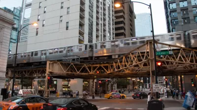
A "TOD Calculator" developed by a Chicago non-profit promises to deliver quantifiable, digestible data on the community impacts of transit-oriented development.
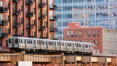
The Grow Chicago "TOD Calculator," created by the Metropolitan Planning Council, uses public data to visualize information on a specific address in Chicago—from its zoning code and proximity to transit, to projections of the annual retail revenue, tax income, on-site jobs, and transit ridership a project built there could generate.
Since its release six months ago, developers, residents, aldermen, and small business owners have used the calculator to judge the impact of potential projects on their own communities.
The data has also influenced regulation—helping convince Chicago to expand its 2013 TOD ordinance by increasing the allowed distance from transit, eliminating parking minimums, and adding density bonuses.
Chicago is hardly the first city to look to open data projects for efficiency, transparency, and shared information to help guide policy. But as Sean Thorton, a fellow with Harvard’s Data-Smart City Solutions initiative, points out, data tech alone is not a magical fix for human, urban problems:
It’s true that without open data, the Calculator would not have been possible to build. Yet MPC’s creative work shows that the effectiveness of data portals themselves also has a ceiling. In order for open data to reach its full potential, those who consume it must be willing to take on complex tasks—like MPC and its partners did—to create tools and products that effectively educate and benefit the public.
The Grow Chicago interactive tool has been joined in recent months by other open data portals, such as OpenGrid in Chicago and GeoHub in Los Angeles.
FULL STORY: How Open Data Can Help Encourage More Transit-Oriented Development


Expanding Chicago TOD Zones Could Boost Transit Ridership
Data indicates broadening the definition of transit-oriented zones to include more of the city would put housing within easy reach of transit for more residents and increase ridership.

Chicago Passes Equitable TOD Ordinance
The new legislation will promote more development near transit in the city’s underserved neighborhoods and improve safety for pedestrians and other road users.
Chicago Grants Support Equitable Transit-Oriented Development
The eTOD program centers equity as a consideration for new projects.

Alabama: Trump Terminates Settlements for Black Communities Harmed By Raw Sewage
Trump deemed the landmark civil rights agreement “illegal DEI and environmental justice policy.”

Planetizen Federal Action Tracker
A weekly monitor of how Trump’s orders and actions are impacting planners and planning in America.

The 120 Year Old Tiny Home Villages That Sheltered San Francisco’s Earthquake Refugees
More than a century ago, San Francisco mobilized to house thousands of residents displaced by the 1906 earthquake. Could their strategy offer a model for the present?

In Both Crashes and Crime, Public Transportation is Far Safer than Driving
Contrary to popular assumptions, public transportation has far lower crash and crime rates than automobile travel. For safer communities, improve and encourage transit travel.

Report: Zoning Reforms Should Complement Nashville’s Ambitious Transit Plan
Without reform, restrictive zoning codes will limit the impact of the city’s planned transit expansion and could exclude some of the residents who depend on transit the most.

Judge Orders Release of Frozen IRA, IIJA Funding
The decision is a victory for environmental groups who charged that freezing funds for critical infrastructure and disaster response programs caused “real and irreparable harm” to communities.
Urban Design for Planners 1: Software Tools
This six-course series explores essential urban design concepts using open source software and equips planners with the tools they need to participate fully in the urban design process.
Planning for Universal Design
Learn the tools for implementing Universal Design in planning regulations.
Clanton & Associates, Inc.
Jessamine County Fiscal Court
Institute for Housing and Urban Development Studies (IHS)
City of Grandview
Harvard GSD Executive Education
Toledo-Lucas County Plan Commissions
Salt Lake City
NYU Wagner Graduate School of Public Service