


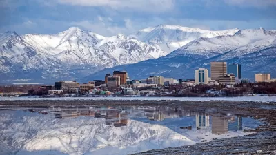
After 34 years the Municipality of Anchorage is updating its land use plan map, a companion piece to its comprehensive plan adopted in 2001. The land use plan map sets the stage for future growth and development in this Northern City of 301,000.
APRN reporter Josh Edge writes, "The most-recent projections – which have been adjusted since the price of oil has declined – anticipate Anchorage’s population will grow between 15,000 and 45,000 people within the next 25 years. That means city planners need to figure out how Anchorage can change to accommodate the growth."
One third of the state's population and nearly half of its jobs puts Anchorage at the heart of an emerging metro region. The Land Use Plan Map update incorporates significant analysis of Anchorage's demographics and projected growth; current and future economic changes; current land sues; and future land capacity. This data informs the policies and strategies included in the LUPM update. Once adopted, the LUPM will provide guidance when developing other plans and making land use and development decisions, public infrastructure investments, and evaluating proposed zoning changes, in coordination with other elements of the Comprehensive Plan.
FULL STORY: Municipality updating Anchorage’s dated land use plan

Anchorage Leaders Support Multigenerational Housing Model
The city is making it easier to build multigenerational housing that can accommodate families, children, and seniors who want to ‘age in place.’

Anchorage Bus Depot to Reopen
After a four-year closure, a downtown Anchorage transit center will once again provide indoor waiting areas and services for bus travelers.

ForwardDallas Lays out Bold Vision, Lacks Teeth
The land use plan outlines ambitious goals for the city’s future, but offers little in the way of concrete changes.

Alabama: Trump Terminates Settlements for Black Communities Harmed By Raw Sewage
Trump deemed the landmark civil rights agreement “illegal DEI and environmental justice policy.”

Planetizen Federal Action Tracker
A weekly monitor of how Trump’s orders and actions are impacting planners and planning in America.

The 120 Year Old Tiny Home Villages That Sheltered San Francisco’s Earthquake Refugees
More than a century ago, San Francisco mobilized to house thousands of residents displaced by the 1906 earthquake. Could their strategy offer a model for the present?

Ken Jennings Launches Transit Web Series
The Jeopardy champ wants you to ride public transit.

BLM To Rescind Public Lands Rule
The change will downgrade conservation, once again putting federal land at risk for mining and other extractive uses.

Indy Neighborhood Group Builds Temporary Multi-Use Path
Community members, aided in part by funding from the city, repurposed a vehicle lane to create a protected bike and pedestrian path for the summer season.
Urban Design for Planners 1: Software Tools
This six-course series explores essential urban design concepts using open source software and equips planners with the tools they need to participate fully in the urban design process.
Planning for Universal Design
Learn the tools for implementing Universal Design in planning regulations.
Clanton & Associates, Inc.
Jessamine County Fiscal Court
Institute for Housing and Urban Development Studies (IHS)
City of Grandview
Harvard GSD Executive Education
Toledo-Lucas County Plan Commissions
Salt Lake City
NYU Wagner Graduate School of Public Service