


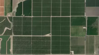
A map-making effort by The Washington Post's Wonkblog puts the Western United States' population, or lack thereof, in perspective.

"I don't know about you, but I'm a sucker for those maps that show the crazy geographic concentration of things like wealth and population," begins a recent post. He clearly wasn't talking to us at Planetizen because then he would know that we are a sucker for those maps that show crazy geographic concentration of things like wealth and population.
The map Ingraham shared with his audience on this occasion is meant to illustrate the "jaw-dropping emptiness of America." Sourced from Reddit, the original map shows "the enormous chunk of land where only 1 percent of the population lives." Ingraham updated the map for a bit more legibility and with the 2014 population numbers from the U.S. Census.
Ingraham provides a few different ways of putting the data shown on the map in perspective, in addition to offering one very specific mark of distinction:
The least-populated place in the United States is Alaska's Yukon-Koyukuk Census Area. At over 145,000 square miles, it's larger than New York, Pennsylvania, Maryland and Virginia -- combined. But it's home to only 5,547 people, for a population density of fewer than 4 people every 100 miles.
FULL STORY: Look at the jaw-dropping emptiness of America

Facebook AI Maps Population Density
Facebook expects to release its worldwide maps of human density in the coming months—potential applications will likely be somewhere on the spectrum between humanitarian and commercial.
DOT Memo Directs Transportation Funding to Communities With Higher Marriage and Birth Rates, Compliance with Immigration Officials and No Mask Mandates
The memo ties immigration enforcement to federal funding and prohibits mask or vaccine mandates.

Maps: How Much of Your City is Parking?
The percentage of land dedicated to parking in the central districts of major U.S. cities ranges from 4 percent to as much as 42 percent.

Alabama: Trump Terminates Settlements for Black Communities Harmed By Raw Sewage
Trump deemed the landmark civil rights agreement “illegal DEI and environmental justice policy.”

Study: Maui’s Plan to Convert Vacation Rentals to Long-Term Housing Could Cause Nearly $1 Billion Economic Loss
The plan would reduce visitor accommodation by 25% resulting in 1,900 jobs lost.

Planetizen Federal Action Tracker
A weekly monitor of how Trump’s orders and actions are impacting planners and planning in America.

Wind Energy on the Rise Despite Federal Policy Reversal
The Trump administration is revoking federal support for renewable energy, but demand for new projects continues unabated.

Passengers Flock to Caltrain After Electrification
The new electric trains are running faster and more reliably, leading to strong ridership growth on the Bay Area rail system.

Texas Churches Rally Behind ‘Yes in God’s Back Yard’ Legislation
Religious leaders want the state to reduce zoning regulations to streamline leasing church-owned land to housing developers.
Urban Design for Planners 1: Software Tools
This six-course series explores essential urban design concepts using open source software and equips planners with the tools they need to participate fully in the urban design process.
Planning for Universal Design
Learn the tools for implementing Universal Design in planning regulations.
Caltrans
Smith Gee Studio
Institute for Housing and Urban Development Studies (IHS)
City of Grandview
Harvard GSD Executive Education
Toledo-Lucas County Plan Commissions
Salt Lake City
NYU Wagner Graduate School of Public Service