


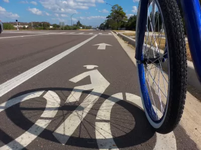
If transportation officials embrace a new approach backed by science, safe and effective mobility no longer need conflict with the multidimensional role of streets as public spaces and with people's varied modes of travel.
In his excellent recent book Street Smart, veteran New York transportation engineer Sam Schwartz recalls a 1980s battle over the Williamsburg Bridge. Schwartz was the city’s transportation commissioner when he received the bad news: The 1903 bridge, which carried a quarter-million New Yorkers daily, was in danger of collapse.
Schwartz faced a choice that required federal funding: Replace the span or repair it. Replacement did not strike Schwartz as the right thing to do. "Had we decided to replace the bridge, New York would have had to spend [an extra] three-quarters of a billion dollars on a bridge whose primary effects would have been to destroy existing neighborhoods on both sides of the East River and put even more cars and trucks on Manhattan streets."
The feds wanted to do just that. The bridge did not fit the prevailing theories on safe streets. The Williamsburg Bridge’s lanes were narrow—less than 9 feet at the towers. To convince the federal government that replacement would be the wrong course, Schwartz mapped traffic collisions on the bridge for a three-year period. It turned out the safest part of the bridge was the narrowest part—even though its lanes there were far short of the standard, recommended 12-foot lane widths. Schwartz’s hypothesis, since confirmed by many studies, is that drivers are more careful when lanes are narrow.
Although the bridge was saved along with (what is now) billions of dollars’ worth of homes and businesses, the findings raised no curiosity in the traffic engineering profession (Traffic engineering is a part of transportation engineering, which comes under civil engineering). No one suggested further studies. The incident was quickly forgotten, except by Schwartz. At least since the 1960s, traffic engineers had designed urban thoroughfares on the theory that wide streets, lacking in nearby obstacles like trees, parked cars, and lampposts, are the safest. To the detriment of people and communities, these designs suppressed other uses of urban streets—such as walking, biking, socializing, and transit—but that outcome was either ignored or deemed an acceptable trade-off.
In a 2005 article called “Safe Streets, Livable Streets,” in the Journal of the American Planning Association, Eric Dumbaugh reported how this design theory came out of conjecture, not science. The definitive research in support of this theory was not a scientific analysis at all, but rather a description of crashes in a particular city, writes the Florida Atlantic University associate professor. When data from academic studies and real-world experience like Schwartz’s contradicted the theory, the data was explained away as aberration.
Dumbaugh cited, at the time, at least 10 studies that contradicted the wisdom of the traffic engineering profession on this subject, and he conducted his own study designed to test the theory of what he calls “forgiving design.” Without a doubt, this concept leads to more injury and death in populated areas. All of the data pointed to a better theory: In urban places, obstacles and constrictions make streets safer, because they cause motor vehicle operators to drive more carefully.
FULL STORY: The new science of traffic engineering


Alabama: Trump Terminates Settlements for Black Communities Harmed By Raw Sewage
Trump deemed the landmark civil rights agreement “illegal DEI and environmental justice policy.”

Planetizen Federal Action Tracker
A weekly monitor of how Trump’s orders and actions are impacting planners and planning in America.

The 120 Year Old Tiny Home Villages That Sheltered San Francisco’s Earthquake Refugees
More than a century ago, San Francisco mobilized to house thousands of residents displaced by the 1906 earthquake. Could their strategy offer a model for the present?

Ken Jennings Launches Transit Web Series
The Jeopardy champ wants you to ride public transit.

BLM To Rescind Public Lands Rule
The change will downgrade conservation, once again putting federal land at risk for mining and other extractive uses.

Indy Neighborhood Group Builds Temporary Multi-Use Path
Community members, aided in part by funding from the city, repurposed a vehicle lane to create a protected bike and pedestrian path for the summer season.
Urban Design for Planners 1: Software Tools
This six-course series explores essential urban design concepts using open source software and equips planners with the tools they need to participate fully in the urban design process.
Planning for Universal Design
Learn the tools for implementing Universal Design in planning regulations.
Clanton & Associates, Inc.
Jessamine County Fiscal Court
Institute for Housing and Urban Development Studies (IHS)
City of Grandview
Harvard GSD Executive Education
Toledo-Lucas County Plan Commissions
Salt Lake City
NYU Wagner Graduate School of Public Service