


Created with input from historian Mark Footer, this tool overlays street views of modern Hong Kong with historical photos from the colonial era through the 20th century.
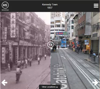
Here's an interesting urban visualization tool, this time featuring an Asian city. Historic Hong Kong interposes old photographs of notable locations onto how the streets look today using Google Street View. Users can hover over the historical photograph to switch between views.
According to outreach specialist Yolanda del Peso, the tool is optimized for mobile users: "If you are looking at it on mobile, or you shrink your browser down to mobile size, you can utilise a fader type functionality where you can literally swipe across to see the street now vs. 100 years ago - giving you what is almost a split screen view."
Planetizen has covered similar tools in the past, including an extensive effort to map wild Manhattan circa 1600.
FULL STORY: Historic Hong Kong

The Look and Feel of 'Inherently Urban'
Greek orators, current solution-based efforts, and 25 photographs remind us of the central role of human opportunity in the urban environment.
Interpreting the 'Timeless and Time-Bound' in Cities
In his latest essay on interpretation of the urban environment, Chuck Wolfe suggests that if we take away context clues cities become matrices -- with blank cells to complete -- where each of us personalizes how space meets time.
Hong Kong Cab Hailing App Folds — and Uber Takes Over
HKTaxi launched a year before Uber came to town. Now, it’s shutting down. Lawmakers worry a monopoly looms.

Alabama: Trump Terminates Settlements for Black Communities Harmed By Raw Sewage
Trump deemed the landmark civil rights agreement “illegal DEI and environmental justice policy.”

Planetizen Federal Action Tracker
A weekly monitor of how Trump’s orders and actions are impacting planners and planning in America.

The 120 Year Old Tiny Home Villages That Sheltered San Francisco’s Earthquake Refugees
More than a century ago, San Francisco mobilized to house thousands of residents displaced by the 1906 earthquake. Could their strategy offer a model for the present?

In Both Crashes and Crime, Public Transportation is Far Safer than Driving
Contrary to popular assumptions, public transportation has far lower crash and crime rates than automobile travel. For safer communities, improve and encourage transit travel.

Report: Zoning Reforms Should Complement Nashville’s Ambitious Transit Plan
Without reform, restrictive zoning codes will limit the impact of the city’s planned transit expansion and could exclude some of the residents who depend on transit the most.

Judge Orders Release of Frozen IRA, IIJA Funding
The decision is a victory for environmental groups who charged that freezing funds for critical infrastructure and disaster response programs caused “real and irreparable harm” to communities.
Urban Design for Planners 1: Software Tools
This six-course series explores essential urban design concepts using open source software and equips planners with the tools they need to participate fully in the urban design process.
Planning for Universal Design
Learn the tools for implementing Universal Design in planning regulations.
Clanton & Associates, Inc.
Jessamine County Fiscal Court
Institute for Housing and Urban Development Studies (IHS)
City of Grandview
Harvard GSD Executive Education
Toledo-Lucas County Plan Commissions
Salt Lake City
NYU Wagner Graduate School of Public Service