


Open data can be a powerful tool for illustrating the risks to public safety that will have to be overcome as more cities adopt Vision Zero initiatives.
"Montgomery County now publishes detailed traffic violation data, which goes online daily here," according to a post by Jacob Mason. "This data allows anyone to see where and when the police are issuing citations, and to whom." Mason used that data, for instance, to create a map of speeding violations covering June 1 through August 16. On the map, the size of the bubbles representing violations even correspond to how far over the speed limit the driver was traveling when cited.
With the map as an illustration, Mason argues for more and better open data projects by local governments. Mason pays specific attention to the Washington, D.C.'s region, which he says had made progress but can still improve.
FULL STORY: When governments make road data public, anyone can help make roads safer


Let’s End Traffic Stops
The technology to make traffic enforcement obsolete is becoming available. But in the U.S. willing to use it?
When it Comes to Road Diets, Evidence Doesn't Matter
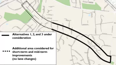
Drivers are a powerful enough lobby to overcome all evidence of the need to redesign streets for safety. Examples from Maryland and Virginia provide the latest case studies in Vision Zero futility.
Speeding Camera Issues 6,000 Tickets in a Day—Is it Unfair?
After issuing 6,000 speeding tickets in one day, a speeding camera in Sheepshead Bay in New York City has already influenced driving habits. But some in the community are calling the location of the cameras a trap.

Alabama: Trump Terminates Settlements for Black Communities Harmed By Raw Sewage
Trump deemed the landmark civil rights agreement “illegal DEI and environmental justice policy.”

Planetizen Federal Action Tracker
A weekly monitor of how Trump’s orders and actions are impacting planners and planning in America.

The 120 Year Old Tiny Home Villages That Sheltered San Francisco’s Earthquake Refugees
More than a century ago, San Francisco mobilized to house thousands of residents displaced by the 1906 earthquake. Could their strategy offer a model for the present?

Ken Jennings Launches Transit Web Series
The Jeopardy champ wants you to ride public transit.

BLM To Rescind Public Lands Rule
The change will downgrade conservation, once again putting federal land at risk for mining and other extractive uses.

Indy Neighborhood Group Builds Temporary Multi-Use Path
Community members, aided in part by funding from the city, repurposed a vehicle lane to create a protected bike and pedestrian path for the summer season.
Urban Design for Planners 1: Software Tools
This six-course series explores essential urban design concepts using open source software and equips planners with the tools they need to participate fully in the urban design process.
Planning for Universal Design
Learn the tools for implementing Universal Design in planning regulations.
Clanton & Associates, Inc.
Jessamine County Fiscal Court
Institute for Housing and Urban Development Studies (IHS)
City of Grandview
Harvard GSD Executive Education
Toledo-Lucas County Plan Commissions
Salt Lake City
NYU Wagner Graduate School of Public Service