


Honolulu's one protected bike lane on King Street, while still a pilot project, has proven so successful that the city plans a major expansion to form a protected bike lane grid that will also tie-in with the new bike share and rail transit.
Honolulu's strategy to deal with "crippling car traffic" is to build more lanes—protected bicycle lanes, that is. More specifically, a "grid" of these lanes that have been shown to increase cycling by addressing the safety factor.
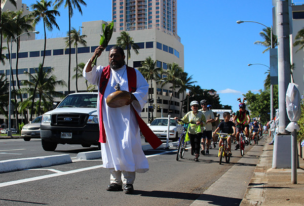
An opening ceremony for King Street's protected bike lane in December. Photo: Being 808 via PeopleForBikes.
Plans call for protected bike lanes to be built on South Street and on the "mauka-makai routes to be installed eventually on Ward Avenue, Keeaumoku, McCully, Pensacola and Piikoi streets," writes Marcel Honoré for the Honolulu Star-Advertiser. The plans were unveiled at a Tuesday meeting on the protected bike lane network.
The expansion ties in with two other transportation projects: the future bikeshare and the city's future elevated guideway, operational by 2019 according to plan if all goes well. Plans were unveiled at the meeting "to eventually install a protected bike lane on Halekauwila Street," underneath the guideway.
“These aren’t just bike projects, they’re policy statements” that include redesigning local streets so that they provide more options than just cars, city Department of Transportation Services Director Mike Formby said.
The new lanes will supplement "the King Street protected lane, also known as the cycle track, a pilot project installed on the mauka side of the street about nine months ago at a cost of about $500,000," writes Honoré. "The city removed 11 parking spaces on the outside of the lane to improve visibility, deputy director of transportation Mark Garrity told the (Tuesday meeting) crowd."
Hat tip to AASHTO's Daily Journal Update: Pedestrians/Bicycles section.
FULL STORY: City looks to more protected bike lanes to deal with traffic

Bike Lanes Help Sidewalks, Too
A growing body of evidence shows that bike lanes put more people on bikes while also helping those people on bikes stay off sidewalks. The latest example: Honolulu.
Houston Mayor Promises Dedicated Austin Street Bike Lane After Public Backlash
Although the one-way bike lane won’t be protected by physical barriers, the proposal is an improvement over the mayor’s initial plan to only include sharrows on the Austin Street project.

Honolulu's Iwilei Center Plans for Redevelopment Into Mixed-Use Space
Striving to expand affordable housing options for Oahu residents, Honolulu's Department of Land Management requests to redevelop the Iwilei Center into a mixed-use space.

Alabama: Trump Terminates Settlements for Black Communities Harmed By Raw Sewage
Trump deemed the landmark civil rights agreement “illegal DEI and environmental justice policy.”

Planetizen Federal Action Tracker
A weekly monitor of how Trump’s orders and actions are impacting planners and planning in America.

The 120 Year Old Tiny Home Villages That Sheltered San Francisco’s Earthquake Refugees
More than a century ago, San Francisco mobilized to house thousands of residents displaced by the 1906 earthquake. Could their strategy offer a model for the present?

Indy Neighborhood Group Builds Temporary Multi-Use Path
Community members, aided in part by funding from the city, repurposed a vehicle lane to create a protected bike and pedestrian path for the summer season.

Congestion Pricing Drops Holland Tunnel Delays by 65 Percent
New York City’s contentious tolling program has yielded improved traffic and roughly $100 million in revenue for the MTA.

In Both Crashes and Crime, Public Transportation is Far Safer than Driving
Contrary to popular assumptions, public transportation has far lower crash and crime rates than automobile travel. For safer communities, improve and encourage transit travel.
Urban Design for Planners 1: Software Tools
This six-course series explores essential urban design concepts using open source software and equips planners with the tools they need to participate fully in the urban design process.
Planning for Universal Design
Learn the tools for implementing Universal Design in planning regulations.
Clanton & Associates, Inc.
Jessamine County Fiscal Court
Institute for Housing and Urban Development Studies (IHS)
City of Grandview
Harvard GSD Executive Education
Toledo-Lucas County Plan Commissions
Salt Lake City
NYU Wagner Graduate School of Public Service