


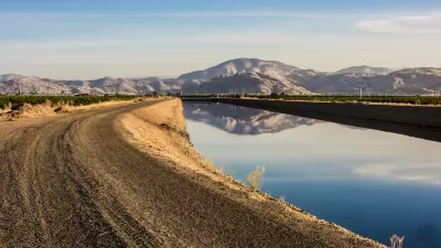
Parts of the nation's food basket, the San Joaquin Valley in California, are sinking at two inches per month, not per year. Known as subsidence, it results from over-pumping of groundwater by farmers desperate to save their crops in the epic drought.
A new report from the National Aeronautics and Space Administration (NASA) showing startling satellite images of California's Central Valley has gotten the attention of California water officials as it reveals that the southern part, known as the San Joaquin Valley, is sinking at historic levels, reports Nathan Rott for NPR in this radio article (with transcript). Listen here. The subsidence has already affected the region's infrastructure.
"(P)erhaps most troubling was that land near some parts of the California Aqueduct, which moves water (from) the northern end of the state to the south, has sunk more than a foot," states Rott.
"The sinking of the surfaces can result in significant damage to infrastructure like canals, aqueducts and bridges," according to Mark Cowin, director of the Department of Water Resources. "He wouldn't say how much damage has already occurred in the state, but his office pointed to a $2.5 million bridge repair job in Mendota County [sic] as an example of what subsidence can do."
[Correspondent's note: I suspect this may be the bridge over the Delta-Mendota Canal in Fresno County shown on page 2 of press release noted below.]
The northern part of the Central Valley is affected as well. "One area in the Sacramento Valley was sinking approximately half-an-inch per month, faster than previous measurements," states the DWR press release (PDF)." In addition to infrastructure damage, "(o)ver time, subsidence can permanently reduce the underground aquifer’s water storage capacity," notes the press release.
Legislation to restrict groundwater pumping was passed last year but does not go into effect until 2020, states Rott. The "Sustainable Groundwater Management Act, enacted by Governor Edmund G. Brown Jr. in September 2014, requires local governments to form sustainable groundwater agencies that will regulate pumping and recharge to better manage groundwater supplies," notes the press release.
The 34-page NASA report was written by Tom G Farr, Cathleen Jones, and Zhen Liu of the Jet Propulsion Laboratory of the California Institute of Technology.
Planetizen posts dated December 2009 and January 2010 describe reports of subsidence in the Valley based on NASA satellite imaging and led by University of California at Irvine Earth Science Professor Jay Famiglietti are here and here.
FULL STORY: Drilling Deeper Wells Contributes To California's Subsidence Problem


Voters to Decide on Repair of Vital Aqueduct for San Joaquin Valley
California voters in November will have the opportunity to help repair the Friant-Kern Canal, damaged by subsidence, as well as invest in watershed conservation programs, by passing a citizen-initiated $8.9 billion general obligation bond measure.
More of California's Central Valley Is Sinking
Over taxed groundwater supplies are causing the ground to sink in the Central Valley. Subsidence has been identified in a new location, farther south than previous incidents.
The Equity of Tiered Water Pricing
A tale of two water-parched cities, one in California, the other in New Mexico, and the critical role played by tiered water pricing. Long known as an effective economic strategy to reduce consumption, tiered pricing also influences equity.

Trump Administration Could Effectively End Housing Voucher Program
Federal officials are eyeing major cuts to the Section 8 program that helps millions of low-income households pay rent.

Planetizen Federal Action Tracker
A weekly monitor of how Trump’s orders and actions are impacting planners and planning in America.

Ken Jennings Launches Transit Web Series
The Jeopardy champ wants you to ride public transit.

California Invests Additional $5M in Electric School Buses
The state wants to electrify all of its school bus fleets by 2035.

Austin Launches $2M Homelessness Prevention Fund
A new grant program from the city’s Homeless Strategy Office will fund rental assistance and supportive services.

Alabama School Forestry Initiative Brings Trees to Schoolyards
Trees can improve physical and mental health for students and commnity members.
Urban Design for Planners 1: Software Tools
This six-course series explores essential urban design concepts using open source software and equips planners with the tools they need to participate fully in the urban design process.
Planning for Universal Design
Learn the tools for implementing Universal Design in planning regulations.
Ada County Highway District
Clanton & Associates, Inc.
Jessamine County Fiscal Court
Institute for Housing and Urban Development Studies (IHS)
City of Grandview
Harvard GSD Executive Education
Toledo-Lucas County Plan Commissions
Salt Lake City
NYU Wagner Graduate School of Public Service