


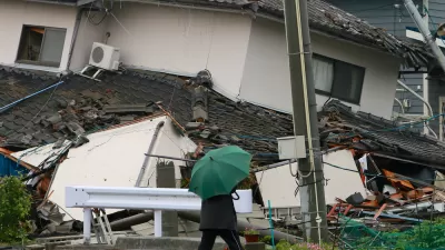
Forget Hollywood's proclivity for destroying Los Angeles and San Francisco in movies like San Andreas—the greatest seismic threat in North America is in the Pacific Northwest.
Kathryn Schulz provides an in-depth look at an under appreciated seismic threat on the West Coast—not the San Andreas fault, but the Cascadia subduction zone. Writes Schulz: "Just north of the San Andreas, however, lies another fault line. Known as the Cascadia subduction zone, it runs for seven hundred miles off the coast of the Pacific Northwest, beginning near Cape Mendocino, California, continuing along Oregon and Washington, and terminating around Vancouver Island, Canada."
Schulz begins by citing the example of Japan's 2011 Tohoku earthquake, which reached a 9.0 on the Richter scale, to illustrate how deadly an event along the Cascadia subduction zone could be. The upper limit of Cascadia's potential is thought to be 9.2. For comparison's sake, the upper limit of the San Andreas Fault's power is estimated at 8.2.
The article goes on to describe, in vivid detail, what would happen in the even of the "Really Big One," which experts speculate would be the worst natural disaster in North American history. According to Kenneth Murphy, who directs FEMA's Region X, "everything west of Interstate 5 will be toast." Adds Schulz: "Everything west of Interstate 5 includes "Seattle, Tacoma, Portland, Eugene, Salem (the capital city of Oregon), Olympia (the capital of Washington), and some seven million people." That would kill an estimated 13,000 people. Schulz also cites the expertise of Chris Goldfinger, who puts the odds of such an event occurring in the next 50 years at one in three.
The article concludes with in an incredible accounting of geologic history, describing the work of historians and geologists in the United States and Japan to find evidence of the last major earthquake on the Cascadia subduction zone in 1700.
FULL STORY: The Really Big One

When the Earth Turns to Liquid
A 7.5 magnitude earthquake struck the Indonesian island of Sulawesi on Sept. 25, followed by a massive tsunami. Soil liquefaction caused by the tremor resulted in 1,700 homes being "swallowed" as the soil shifted. Deaths exceeded 1,400 on Oct. 3.
A New Earthquake Warning System for the Pacific Northwest
Oregon and Washington are implementing sensors that can detect and report an earthquake to communities with as much as a minute or two of warning.
Worst-Case Tsunami Scenario Mapped
The event of a huge earthquake off the Aleutian Islands could send a devastating tsunami towards the West coast of the U.S. Researchers have released maps of what a worst-case scenario might look like for coastal communities.

Trump Administration Could Effectively End Housing Voucher Program
Federal officials are eyeing major cuts to the Section 8 program that helps millions of low-income households pay rent.

Planetizen Federal Action Tracker
A weekly monitor of how Trump’s orders and actions are impacting planners and planning in America.

Ken Jennings Launches Transit Web Series
The Jeopardy champ wants you to ride public transit.

Washington Legislature Passes Rent Increase Cap
A bill that caps rent increases at 7 percent plus inflation is headed to the governor’s desk.

From Planning to Action: How LA County Is Rethinking Climate Resilience
Chief Sustainability Officer Rita Kampalath outlines the County’s shift from planning to implementation in its climate resilience efforts, emphasizing cross-departmental coordination, updated recovery strategies, and the need for flexible funding.

New Mexico Aging Department Commits to Helping Seniors Age ‘In Place’ and ‘Autonomously’ in New Draft Plan
As New Mexico’s population of seniors continues to grow, the state’s aging department is proposing expanded initiatives to help seniors maintain their autonomy while also supporting family caregivers.
Urban Design for Planners 1: Software Tools
This six-course series explores essential urban design concepts using open source software and equips planners with the tools they need to participate fully in the urban design process.
Planning for Universal Design
Learn the tools for implementing Universal Design in planning regulations.
Heyer Gruel & Associates PA
Ada County Highway District
Institute for Housing and Urban Development Studies (IHS)
City of Grandview
Harvard GSD Executive Education
Toledo-Lucas County Plan Commissions
Salt Lake City
NYU Wagner Graduate School of Public Service