


Until last week, the seasons never changed on satellite image software. But Mapbox's Landsat-Live program shares clear images of the Earth's surface in near-real time.
"Launched Thursday, a landmark project from Mapbox has changed the summertime paradigm for online cartography," reports Laura Bliss. "Landsat-live reveals the planet's surface in real time and in stunning resolution, fed by a constant stream of public-domain imagery from NASA’s Landsat 8 satellite."
Bliss goes on to detail the features of the new addition to the cartography toolbox, including giving credit to the U.S. Geological Survey and Amazon Web Services for making the images free and available to the public.
The result is satellite imagery that is 16 days old at the most, according to Bliss, which enables all kinds of practical applications, such as environmental and agricultural monitoring. The article also includes an embedded version and screengrabs from the Landsat-live app.
FULL STORY: Roam the World in (Almost) Real Time

Can an Upstart Mapmaker Beat Google and Microsoft at Their Own Game?
Glenn Fleishman profiles MapBox, whose 30 employees are taking on the big boys in the development of interactive street and satellite maps. The company is working with Charlie Loyd to develop "the most beautiful, clean map ever made."

Satellite, Launched Into Space Earlier This Month, to Measure Urban Heat Island Effect
A new satellite, currently residing on the International Space Station and scheduled for deployment in January, will measure and map the urban heat island effect of seven U.S. cities.
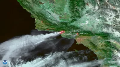
View the Smoke from the California Fires From Satellite
The National Oceanic and Atmospheric Administration has been making the most of its celestial perch to illustrate the scale of the fires currently burning in Southern California.

Alabama: Trump Terminates Settlements for Black Communities Harmed By Raw Sewage
Trump deemed the landmark civil rights agreement “illegal DEI and environmental justice policy.”

Planetizen Federal Action Tracker
A weekly monitor of how Trump’s orders and actions are impacting planners and planning in America.

How Atlanta Built 7,000 Housing Units in 3 Years
The city’s comprehensive, neighborhood-focused housing strategy focuses on identifying properties and land that can be repurposed for housing and encouraging development in underserved neighborhoods.

In Both Crashes and Crime, Public Transportation is Far Safer than Driving
Contrary to popular assumptions, public transportation has far lower crash and crime rates than automobile travel. For safer communities, improve and encourage transit travel.

Report: Zoning Reforms Should Complement Nashville’s Ambitious Transit Plan
Without reform, restrictive zoning codes will limit the impact of the city’s planned transit expansion and could exclude some of the residents who depend on transit the most.

Judge Orders Release of Frozen IRA, IIJA Funding
The decision is a victory for environmental groups who charged that freezing funds for critical infrastructure and disaster response programs caused “real and irreparable harm” to communities.
Urban Design for Planners 1: Software Tools
This six-course series explores essential urban design concepts using open source software and equips planners with the tools they need to participate fully in the urban design process.
Planning for Universal Design
Learn the tools for implementing Universal Design in planning regulations.
Jessamine County Fiscal Court
Caltrans
Institute for Housing and Urban Development Studies (IHS)
City of Grandview
Harvard GSD Executive Education
Toledo-Lucas County Plan Commissions
Salt Lake City
NYU Wagner Graduate School of Public Service