


A new satellite, currently residing on the International Space Station and scheduled for deployment in January, will measure and map the urban heat island effect of seven U.S. cities.

Arizona State University students built a satellite named CubeSat that launched this month into space on an Antares rocket.
Ian James reports on the recent launch of the satellite, known as CubeSat, which measures only 12 inches long by 4 inches wide and weighed 8.6 pounds. Cubesat was engineered to capture block-by-block, infrared images of Phoenix and six other U.S. cities. The resulting data on heat trends "could help urban planners design cooler cityscapes to withstand the effects as the world continues to heat up due to the burning of fossil fuels," according to the article.
"Four years ago, the students wrote a proposal to build the satellite and obtained $200,000 in NASA funding," explains James of how the project came to be. "A total of about 80 undergraduate students took part in the project. Many of them spent long hours designing the spacecraft, piecing together the components, testing its systems, and writing code to make it all work."
"In addition to focusing on Phoenix, the plan is for the satellite to gather thermal images of Los Angeles, Chicago, Houston, Atlanta, Baltimore and Minneapolis," adds James, who also provides details of how the new data will be used to create new forms of climate mapping for the cities under study.
FULL STORY: Satellite built by students soars to space on mission to map heat in Phoenix, other cities

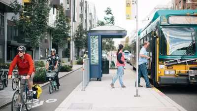
As Heat Waves Become More Common, Bus Shelters Are Needed to Keep Transit Riders Onboard
As climate change brings prolonged, intense heat waves to cities once associated with rain and cold weather will have to attend to the lack of shelter provided to bus and transit riders.

Planting Relief: Tackling Las Vegas Heat One Tree at a Time
Nevada Plants, a Las Vegas-based nonprofit, is combating the city’s extreme urban heat by giving away trees to residents in underserved neighborhoods, promoting shade, sustainability, and community health.

Key Climate and Health Issues to Watch in 2025
The escalating health impacts of climate change, from extreme heat to sea level rise, highlight the urgent need for integrated medical education, proactive communication, and sustainable policy solutions to protect public health.

Study: Maui’s Plan to Convert Vacation Rentals to Long-Term Housing Could Cause Nearly $1 Billion Economic Loss
The plan would reduce visitor accommodation by 25,% resulting in 1,900 jobs lost.

North Texas Transit Leaders Tout Benefits of TOD for Growing Region
At a summit focused on transit-oriented development, policymakers discussed how North Texas’ expanded light rail system can serve as a tool for economic growth.

Why Should We Subsidize Public Transportation?
Many public transit agencies face financial stress due to rising costs, declining fare revenue, and declining subsidies. Transit advocates must provide a strong business case for increasing public transit funding.

How to Make US Trains Faster
Changes to boarding platforms and a switch to electric trains could improve U.S. passenger rail service without the added cost of high-speed rail.

Columbia’s Revitalized ‘Loop’ Is a Hub for Local Entrepreneurs
A focus on small businesses is helping a commercial corridor in Columbia, Missouri thrive.

Invasive Insect Threatens Minnesota’s Ash Forests
The Emerald Ash Borer is a rapidly spreading invasive pest threatening Minnesota’s ash trees, and homeowners are encouraged to plant diverse replacement species, avoid moving ash firewood, and monitor for signs of infestation.
Urban Design for Planners 1: Software Tools
This six-course series explores essential urban design concepts using open source software and equips planners with the tools they need to participate fully in the urban design process.
Planning for Universal Design
Learn the tools for implementing Universal Design in planning regulations.
Ascent Environmental
Borough of Carlisle
Institute for Housing and Urban Development Studies (IHS)
City of Grandview
Harvard GSD Executive Education
Toledo-Lucas County Plan Commissions
Salt Lake City
NYU Wagner Graduate School of Public Service