


Mapping the nation's 600,000 bridges reveals a remarkably fine-grained map of…the nation.

"In his 2016 budget, President Obama proposed a one-time tax on foreign earnings in order to fund a $478 billion program to upgrade the nation's roads, bridges, railroads and more. As policymakers debate the merits of the proposal in coming months, it helps to visualize what exactly we're talking about when we talk about the nation's infrastructure," writes Christopher Ingraham.
To create a resource to aid in that visualization, Wonkblog used data from the Federal Highway Administration's National Bridge Inventory and mapped every bridge in the United States longer than 20 feet.
Ingraham adds more language helpful in setting a political context for the mapping exercise: "The map illustrates the ubiquity of America's [sic] bridges -- it's basically impossible to go for a drive in any densely-populated area and not cross one. But each of those bridges -- all 600,000 of them -- need to be maintained. This maintenance costs money. And some states and localities do a better job of it than others."
FULL STORY: A surprisingly accurate map of the U.S. made with 600,000 bridges — and nothing else


Massachusetts Gov. Makes Case for Road Funding Reforms
A package of proposed bills would change the state’s road funding formula to ensure more money flows to rural areas with limited resources.
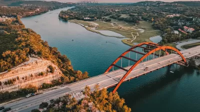
Texas Infrastructure Gets a ‘C’
The American Society of Civil Engineers rates states in 16 categories related to transportation, water, waste management, parks, and more.
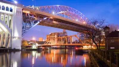
Defunct Streetcar Bridge Could Become Cleveland’s ‘Low Line’
The city will develop a plan to transform an unused streetcar deck on the Veterans Memorial Bridge into a connector for bikes and pedestrians as well as a welcoming public space.

Study: Maui’s Plan to Convert Vacation Rentals to Long-Term Housing Could Cause Nearly $1 Billion Economic Loss
The plan would reduce visitor accommodation by 25,% resulting in 1,900 jobs lost.

North Texas Transit Leaders Tout Benefits of TOD for Growing Region
At a summit focused on transit-oriented development, policymakers discussed how North Texas’ expanded light rail system can serve as a tool for economic growth.

Using Old Oil and Gas Wells for Green Energy Storage
Penn State researchers have found that repurposing abandoned oil and gas wells for geothermal-assisted compressed-air energy storage can boost efficiency, reduce environmental risks, and support clean energy and job transitions.

Santa Barbara Could Build Housing on County Land
County supervisors moved forward a proposal to build workforce housing on two county-owned parcels.

San Mateo Formally Opposes Freeway Project
The city council will send a letter to Caltrans urging the agency to reconsider a plan to expand the 101 through the city of San Mateo.

A Bronx Community Fights to Have its Voice Heard
After organizing and giving input for decades, the community around the Kingsbridge Armory might actually see it redeveloped — and they want to continue to have a say in how it goes.
Urban Design for Planners 1: Software Tools
This six-course series explores essential urban design concepts using open source software and equips planners with the tools they need to participate fully in the urban design process.
Planning for Universal Design
Learn the tools for implementing Universal Design in planning regulations.
Ascent Environmental
Borough of Carlisle
Institute for Housing and Urban Development Studies (IHS)
City of Grandview
Harvard GSD Executive Education
Toledo-Lucas County Plan Commissions
Salt Lake City
NYU Wagner Graduate School of Public Service