


A new service provides transit users live, real-time displays of all transportation options within proximity to various locations in downtown Seattle, Washington.
As discussed on the Seattle Transit Blog by Frank Chiachiere, the Seattle Department of Transportation has teamed up with TransitScreen to provide readable multi-modal information to transit riders. The screens contain easy to read information on bus and rail arrival times, and bike-share and carshare location and availability, so that riders can make informed decisions as to their travel mode choice.
Following the lead of a number of other North American cities such as Washington D.C., San Francisco, Salt Lake City, and San Diego, Seattle has been working hard to implement new technologies making riding transit easier to understand and more transparent.
However, as Chiachiere points out, Seattle still does not have a standardized wayfinding method to pinpoint transit locations, like Vignelli’s 1970 standards manual for New York’s MTA, making the new implementation of TransitScreen perhaps preemptive.
FULL STORY: TransitScreen Launches Downtown

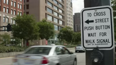
Seattle Recalculates Walk Signal Timing to Make Crossings Safer for Pedestrians
The new formulas for calculating the length of walk signals are designed to give people more time to safely cross the street.

Seattle Neighborhood Groups Propose Aerial Gondola to Replace Light Rail Expansion
Impatient with the city's light rail expansion plans, some residents are looking to aerial gondolas as a new mode of public transit.

Seattle Plans to Connect Bike Network by 2020
Downtown Seattle has many disconnected bike lanes, so to make sure there are more safe routes for bikers, the city council passed a resolution that sets out a timeline to connect them.

Alabama: Trump Terminates Settlements for Black Communities Harmed By Raw Sewage
Trump deemed the landmark civil rights agreement “illegal DEI and environmental justice policy.”

Planetizen Federal Action Tracker
A weekly monitor of how Trump’s orders and actions are impacting planners and planning in America.

The 120 Year Old Tiny Home Villages That Sheltered San Francisco’s Earthquake Refugees
More than a century ago, San Francisco mobilized to house thousands of residents displaced by the 1906 earthquake. Could their strategy offer a model for the present?

Ken Jennings Launches Transit Web Series
The Jeopardy champ wants you to ride public transit.

BLM To Rescind Public Lands Rule
The change will downgrade conservation, once again putting federal land at risk for mining and other extractive uses.

Indy Neighborhood Group Builds Temporary Multi-Use Path
Community members, aided in part by funding from the city, repurposed a vehicle lane to create a protected bike and pedestrian path for the summer season.
Urban Design for Planners 1: Software Tools
This six-course series explores essential urban design concepts using open source software and equips planners with the tools they need to participate fully in the urban design process.
Planning for Universal Design
Learn the tools for implementing Universal Design in planning regulations.
Clanton & Associates, Inc.
Jessamine County Fiscal Court
Institute for Housing and Urban Development Studies (IHS)
City of Grandview
Harvard GSD Executive Education
Toledo-Lucas County Plan Commissions
Salt Lake City
NYU Wagner Graduate School of Public Service