


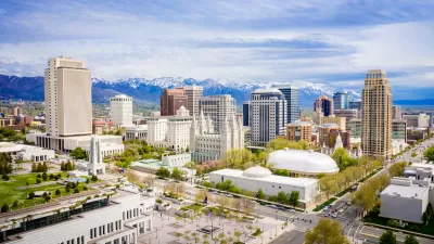
The Poplar Grove and Glendale neighborhoods in Salt Lake City perform poorly on the federal government's "opportunity index." A new master plan, however, would focus on transportation and nodes of activity to revitalize the area.
Christopher Smart details the newly proposed West Side Master Plan for Salt Lake City, which would set a planning vision for the Poplar Grove and Glendale neighborhoods.
Here's how Smart describes the vision set forth by the master plan:
Imagine riding a streetcar from the TRAX station at 200 West 900 South to the intersection of 900 South and 900 West, where a bustling neighborhood of cafes and shops stretches north to 800 South.
There you would find Latin American, African and Eastern European influences from food to clothing to art. Nearby bicycle traffic would flow east and west on the 9 Line, the abandoned rail right of way that parallels Indiana Avenue to Redwood Road. It intersects with Jordan River Parkway and a future nature preserve.
Smart notes that the plan focuses on nodes of activity, rather than painting in broad strokes. In fact, the master plan lacks a development map in the hopes of providing flexibility for would-be developers.
FULL STORY: Salt Lake City’s ‘diamond in the rough’ West Side to be polished

Salt Lake City Looks West for Downtown Revitalization
The Salt Lake Tribune looked at the development plans made possible by the West Side Master Plan for Salt Lake City.
Salt Lake City to Get Five New Bus Lines
The service improvements come after a year of strong ridership growth.

Utah to Build New, 1,200-Bed Shelter Campus
The state’s attempt to decentralize emergency homeless shelters yielded poor results, leading to a decision to develop a “transformative” intake campus with wraparound services.

Alabama: Trump Terminates Settlements for Black Communities Harmed By Raw Sewage
Trump deemed the landmark civil rights agreement “illegal DEI and environmental justice policy.”

Planetizen Federal Action Tracker
A weekly monitor of how Trump’s orders and actions are impacting planners and planning in America.

The 120 Year Old Tiny Home Villages That Sheltered San Francisco’s Earthquake Refugees
More than a century ago, San Francisco mobilized to house thousands of residents displaced by the 1906 earthquake. Could their strategy offer a model for the present?

Ken Jennings Launches Transit Web Series
The Jeopardy champ wants you to ride public transit.

BLM To Rescind Public Lands Rule
The change will downgrade conservation, once again putting federal land at risk for mining and other extractive uses.

Indy Neighborhood Group Builds Temporary Multi-Use Path
Community members, aided in part by funding from the city, repurposed a vehicle lane to create a protected bike and pedestrian path for the summer season.
Urban Design for Planners 1: Software Tools
This six-course series explores essential urban design concepts using open source software and equips planners with the tools they need to participate fully in the urban design process.
Planning for Universal Design
Learn the tools for implementing Universal Design in planning regulations.
Clanton & Associates, Inc.
Jessamine County Fiscal Court
Institute for Housing and Urban Development Studies (IHS)
City of Grandview
Harvard GSD Executive Education
Toledo-Lucas County Plan Commissions
Salt Lake City
NYU Wagner Graduate School of Public Service