


After a failed attempt at similarly broad land use regulations failed in 2011, the Minnesota Department of Natural Resources is again undertaking an outreach process to create land use regulations along 72 miles of the Mississippi River.
The Minnesota Department of Natural Resources is halfway through a two-year process to "revamp land-use rules along the stretch of the Mississippi River that runs through the Twin Cities area," according to Jim Anderson. The process "is once again pitting cities and development interests against environmental concerns."
"[The] rules that would affect 21 cities, five counties and four townships along a 72-mile stretch of river from Dayton to Hastings."
In St. Paul, for instance, "[almost] 2,000 buildings and nearly 3,000 parcels of land in the city would come under new construction limits near bluffs and steep slopes along the river."
The cities want local control over land use regulations, as do developers, while environmentalists would like to limit the amount of exceptions on the table. Another regulation under consideration that has provoked the ire of environmentalist river proponents: "The rules weaken scenic protections by allowing taller buildings along the river, including some of its most beautiful stretches: the gorge near the University of Minnesota, West Side Flats, Pine Bend Bluffs in Inver Grove Heights and the bluff lands of eastern Dakota and southern Washington counties."
FULL STORY: DNR land-use rules draw concerns along the Mississippi riverfront

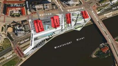
Details of St. Paul Riverfront Plans Emerge
A plan to remake the St. Paul riverfront, and potentially revitalize the downtown office market, took its first steps forward this week.

Controversial Green Neighborhood to Rise on Former Auto Plant Site
Plans for a sizable eco-friendly development on the site of St. Paul's Twin Cities Assembly Plant have drawn support from many, including the city's young mayor. But density opponents remain unconvinced.
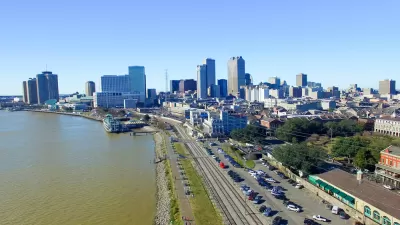
New Orleans Closes Gap in Historic Riverfront Park Plan
New Orleans could create the largest stretch of public riverfront in the U.S., thanks to a public land swap.

Alabama: Trump Terminates Settlements for Black Communities Harmed By Raw Sewage
Trump deemed the landmark civil rights agreement “illegal DEI and environmental justice policy.”

Planetizen Federal Action Tracker
A weekly monitor of how Trump’s orders and actions are impacting planners and planning in America.

The 120 Year Old Tiny Home Villages That Sheltered San Francisco’s Earthquake Refugees
More than a century ago, San Francisco mobilized to house thousands of residents displaced by the 1906 earthquake. Could their strategy offer a model for the present?

Ken Jennings Launches Transit Web Series
The Jeopardy champ wants you to ride public transit.

BLM To Rescind Public Lands Rule
The change will downgrade conservation, once again putting federal land at risk for mining and other extractive uses.

Indy Neighborhood Group Builds Temporary Multi-Use Path
Community members, aided in part by funding from the city, repurposed a vehicle lane to create a protected bike and pedestrian path for the summer season.
Urban Design for Planners 1: Software Tools
This six-course series explores essential urban design concepts using open source software and equips planners with the tools they need to participate fully in the urban design process.
Planning for Universal Design
Learn the tools for implementing Universal Design in planning regulations.
Clanton & Associates, Inc.
Jessamine County Fiscal Court
Institute for Housing and Urban Development Studies (IHS)
City of Grandview
Harvard GSD Executive Education
Toledo-Lucas County Plan Commissions
Salt Lake City
NYU Wagner Graduate School of Public Service