


Want to know the fastest way to get where you're going? You Are Here has created a new visualization tool that shows you the fastest mode for your trip in 11 cities.
Joseph Stromberg shares news of a new series of maps on the You Are Here site (Planetizen also provided earlier coverage of the site) that shows the fastest mode of transportation to get anywhere from a given point in the selected cities.
Here's how the maps work, as explained by You Are Here: "The maps is activated by selecting a specific departure point. Once the departure point is selected, the rest of the city will be colored based on the fastest mode of transportation. The point to which it's fastest to get to by bicycle are colored yellow, by public transit: blue, by walking: green, and by driving: red."
Cities mapped in the series include Manhattan, Portland, Santa Monica, Salt Lake City, and more.
FULL STORY: Best Mode of Transportation

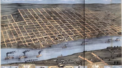
200 Years of Faster Travel Times
A post on Vox collects a series of maps from the "Atlas of the Historical Geography of the United States" showing how travel times changed over the past 200 years of U.S. history.
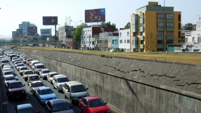
Why and Where Driving is a Rational Choice
A recently released tool for analyzing the efficiency of travel modes in cities around the country reveals that driving is almost always a better choice—at least in travel time—than transit.
Friday Eye Candy: 'You Are Here' Maps the Little Things
The Social Computing Group and the MIT Media Lab have launched the "You Are Here" project, mapping data points from cities where participants have lived. The project has colorful maps of bicycle crashes, coffee shops, and permanent visa applications.

Alabama: Trump Terminates Settlements for Black Communities Harmed By Raw Sewage
Trump deemed the landmark civil rights agreement “illegal DEI and environmental justice policy.”

Planetizen Federal Action Tracker
A weekly monitor of how Trump’s orders and actions are impacting planners and planning in America.

Why Should We Subsidize Public Transportation?
Many public transit agencies face financial stress due to rising costs, declining fare revenue, and declining subsidies. Transit advocates must provide a strong business case for increasing public transit funding.

Understanding Road Diets
An explainer from Momentum highlights the advantages of reducing vehicle lanes in favor of more bike, transit, and pedestrian infrastructure.

New California Law Regulates Warehouse Pollution
A new law tightens building and emissions regulations for large distribution warehouses to mitigate air pollution and traffic in surrounding communities.

Phoenix Announces Opening Date for Light Rail Extension
The South Central extension will connect South Phoenix to downtown and other major hubs starting on June 7.
Urban Design for Planners 1: Software Tools
This six-course series explores essential urban design concepts using open source software and equips planners with the tools they need to participate fully in the urban design process.
Planning for Universal Design
Learn the tools for implementing Universal Design in planning regulations.
Caltrans
Smith Gee Studio
Institute for Housing and Urban Development Studies (IHS)
City of Grandview
Harvard GSD Executive Education
Toledo-Lucas County Plan Commissions
Salt Lake City
NYU Wagner Graduate School of Public Service