


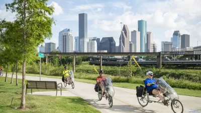
Planners in Houston are working on street configurations in large swaths of the city. The plans reflect Mayor Annise Parker's recent executive order to embrace complete streets as well as a growing demand among residents for walkable, safe streets.
Dug Begley reports on an effort in Houston to send much of the city on a road diet. "…in a departure from what many consider the Houston model, the city is calling for reducing the space for cars and trucks. Plans for Dunlavy, along with a handful of other street segments between River Oaks, downtown and U.S. 59 and along the Washington Avenue corridor, will decrease driving room in favor of retaining trees and making parking, bicycling and walking easier."
"Most of the 2014 changes proposed are inside Loop 610, though a handful would create better connections to industrial areas in the eastern part of the city. Various changes are proposed in newly developed areas on the city's fringes as well."
The amendments to the city's transportation plan would appear in the 2014 major thoroughfare and freeway plan, according to Begley. The City Council is expected to vote on the proposed changes by September.
"What's significant, officials said, is the decision to reduce driving lanes in some spots. The traditional Houston method of improving a four-lane road - turning it into a five- or six-lane road - is falling out of favor in many neighborhoods, with residents reluctant to lose more private land to roads."
The article also includes a video of Houston Transportation Planning Group head Amar Mohite making the case for such changes.
FULL STORY: Street plans call for doing more with less driving room


Houston Residents Respond to Mobility Questions
What could the city look like if budget and bureaucracy were no object?
Houston Developers Question Mayor’s Stance on Pedestrian Projects
The new mayor’s reversal of road safety projects, some already underway or completed, is raising eyebrows among developers who say residents want walkable, mixed-use streets.
Houston Road Safety Project at Risk
Mayor Whitmire reversed his support for a planned road safety project that includes lane reductions, putting $40 million in federal funding in jeopardy.

Trump Administration Could Effectively End Housing Voucher Program
Federal officials are eyeing major cuts to the Section 8 program that helps millions of low-income households pay rent.

Planetizen Federal Action Tracker
A weekly monitor of how Trump’s orders and actions are impacting planners and planning in America.

Ken Jennings Launches Transit Web Series
The Jeopardy champ wants you to ride public transit.

Crime Continues to Drop on Philly, San Francisco Transit Systems
SEPTA and BART both saw significant declines in violent crime in the first quarter of 2025.

How South LA Green Spaces Power Community Health and Hope
Green spaces like South L.A. Wetlands Park are helping South Los Angeles residents promote healthy lifestyles, build community, and advocate for improvements that reflect local needs in historically underserved neighborhoods.

Sacramento Plans ‘Quick-Build’ Road Safety Projects
The city wants to accelerate small-scale safety improvements that use low-cost equipment to make an impact at dangerous intersections.
Urban Design for Planners 1: Software Tools
This six-course series explores essential urban design concepts using open source software and equips planners with the tools they need to participate fully in the urban design process.
Planning for Universal Design
Learn the tools for implementing Universal Design in planning regulations.
Heyer Gruel & Associates PA
Ada County Highway District
Institute for Housing and Urban Development Studies (IHS)
City of Grandview
Harvard GSD Executive Education
Toledo-Lucas County Plan Commissions
Salt Lake City
NYU Wagner Graduate School of Public Service