


Continuing a conversation about the definition of conservation subdivisions, this article examines the inconsistent application of the term by policymakers. Moreover, the auto-dependent realities of rural development require more critical thinking.
In a recent Planetizen post, Randall Arendt claims that a peer-reviewed research paper—published in the Journal of Planning Education and Research—is “seriously flawed” because it “conflates three entirely different kinds of subdivision design” (conservation design, clustering, and planned residential developments). He asserts that these three development types are “built at significantly different densities” and that “the majority of the 54 developments examined by the study fail to meet the minimum open space standard for conservation subdivisions contained in my publications.”
While Mr. Arendt’s consternation is understandable, policing the implementation of a concept as broad as “conservation subdivision design” is an exercise in futility.
Policy inconsistencies
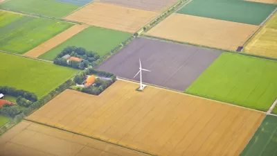
Wisconsin’s Waukesha County—the study area for Dr. Asli Göçmen’s research—allows “conservation subdivisions” that do not adhere to Mr. Arendt’s design standards or to the regional planning commission’s design recommendations. This discrepancy is a research finding with sustainability implications. The Southeastern Wisconsin Regional Planning Commission (SEWRPC) is an advisory agency, and its land development recommendations are not consistently implemented at the local level. Consequently, the municipalities across the seven-county region take widely differing policy approaches to conservation subdivision design. In some areas of the Town of Waukesha, for example, the minimum open space requirement for conservation subdivisions is only 20 percent.[1]
Furthermore, clustering, planned residential development (PRD), and conservation subdivision design (CSD) are terms that could describe a single subdivision. There are no definitive design standards for clustering or PRDs, and even CSD policies vary considerably. SEWRPC’s summary table of subdivision ordinance requirements in southeastern Wisconsin includes this telling footnote:
“Conservation subdivisions may also be referred to as cluster developments, cluster subdivisions, and open space subdivisions, depending on the community.”
Even among the states that have adopted model CSD ordinances, conservation design standards vary. Not all model ordinances require, for example, that half of the development tract’s buildable area be set aside as permanent conservation open space. Also, the minimum open space percentage of the total tract area (including primary conservation areas) is less than 50 percent in some model ordinances. Georgia and South Carolina’s model ordinances set the minimum threshold at 30 percent and 40 percent, respectively.
Sustainability implications
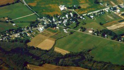
Although rural open space conservation is essential, the world has markedly changed over the past 20 years. Population growth combined with climate change warrant a re-examination of low-density residential development (two or more acres per dwelling) in the rural periphery of metropolitan areas. While rural conservation subdivisions may perform better than large-lot conventional subdivisions on some environmental measures, these residential enclaves still raise ecological—as well as troubling social and economic—implications.
Many of the conservation subdivisions in southeastern Wisconsin are high-end examples of suburban sprawl, catering to affluent homeowners who commute to the region’s more urbanized areas. This auto-dependent development type fares poorly on vehicle-miles traveled per household (a key sustainability indicator with air quality, public health, and climate implications). Other negative effects include the fragmentation of productive farmland—especially in areas with extensive prime agricultural soils. Scattered residential development also increases the costs per household of building and maintaining infrastructure (e.g., roads, utilities) and providing other public services (e.g., bussing to schools, police and fire protection).
Scientific research—scrutinizing the often-messy implementation of the conservation subdivision design concept—is necessary to gain an unbiased assessment of both its benefits and costs.
[1] Southeastern Wisconsin Regional Planning Commission (SEWRPC) -Summary of Ordinance Requirements for Conservation Subdivisions in Southeastern Wisconsin: May 2008.

Clarifying the Conservation Subdivision Design Approach
After a recent scholarly article raising questions about the definition of conservation subdivisions, Randall Arendt, author of "Conservation Design for Subdivisions" and "Growing Greener," wrote the following response.

Commentary: Why We Need a Federal Definition of ‘Rural’
A patchwork of definitions of rural versus urban areas has real consequences for communities seeking federal funding.
Opinion: Ohio Needs Public Transit
A new Intel facility is set to bring thousands of workers to rural Ohio. Will the state embrace mass transit or give in to auto-centric sprawl?

Alabama: Trump Terminates Settlements for Black Communities Harmed By Raw Sewage
Trump deemed the landmark civil rights agreement “illegal DEI and environmental justice policy.”

Planetizen Federal Action Tracker
A weekly monitor of how Trump’s orders and actions are impacting planners and planning in America.

The 120 Year Old Tiny Home Villages That Sheltered San Francisco’s Earthquake Refugees
More than a century ago, San Francisco mobilized to house thousands of residents displaced by the 1906 earthquake. Could their strategy offer a model for the present?

Ken Jennings Launches Transit Web Series
The Jeopardy champ wants you to ride public transit.

BLM To Rescind Public Lands Rule
The change will downgrade conservation, once again putting federal land at risk for mining and other extractive uses.

Indy Neighborhood Group Builds Temporary Multi-Use Path
Community members, aided in part by funding from the city, repurposed a vehicle lane to create a protected bike and pedestrian path for the summer season.
Urban Design for Planners 1: Software Tools
This six-course series explores essential urban design concepts using open source software and equips planners with the tools they need to participate fully in the urban design process.
Planning for Universal Design
Learn the tools for implementing Universal Design in planning regulations.
Clanton & Associates, Inc.
Jessamine County Fiscal Court
Institute for Housing and Urban Development Studies (IHS)
City of Grandview
Harvard GSD Executive Education
Toledo-Lucas County Plan Commissions
Salt Lake City
NYU Wagner Graduate School of Public Service