


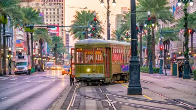
A study of streetcar-adjacent development patterns in New Orleans following Hurricane Katrina provides lessons for the many U.S. cities building and planning new streetcar lines.

Streetcars are undergoing a striking renaissance in America. Many U.S. cities are building or planning lines—even systems. An increasing number of these extend well beyond downtown business districts, the conventional environments of latter-day streetcar lines. Catalyzing vibrant, sustainable neighborhood development is a common project goal; it is also uncharted territory, at least within the last century or so.
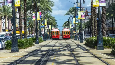
It can be difficult to research the neighborhood development impacts of streetcars: currently, few lines operate outside central business districts, and most that do are surrounded by other rail lines that can make attribution of impacts problematic. New Orleans is an exception, with the second most extensive streetcar system in the nation and no heavier rail transit. Researchers Andrew Guthrie and Yingling Fan of the University of Minnesota recently completed an analysis of building permits issued around New Orleans streetcar lines over roughly two and a half years following Hurricane Katrina. Studying streetcars during the recovery illuminates their impacts on fully built-up neighborhoods due to a flurry of reconstruction and redevelopment activity partly mimicking the introduction of new service.
Guthrie and Fan geocoded permits representing commercial or residential new construction and major repairs, and grouped permits by downtown or neighborhood location and walking distances up to half a mile from streetcar stops. Next, they modeled permit frequency as a function of distance from stops, controlling for storm damage, distance from the central business district and pre-storm concentrations of commercial land use, median income and residential vacancy rates.
Within prime walking distance from streetcar stops, commercial permits in neighborhood areas got roughly 20% more frequent for every 100’ closer to stops. Crucially, distance to streetcar stops was a stronger predictor of commercial permit frequency than distance to pre-existing commercial areas. Residential permits were more common overall, but declined in frequency near stops, in almost a mirror image of the trend found for commercial permits.
New Orleans is a unique city, with many factors influencing development. Still, there are important lessons for cities building or planning streetcar lines (including New Orleans itself) and planning for development in the neighborhoods around them can draw from this research. Most importantly, streetcar lines were able to support economic development and influence land use mix in present-day urban neighborhoods. Second, the decline in residential development found near streetcar stops calls for careful planning around streetcar projects and consideration of potential unintended residential displacement. Streetcars also appear to impact development differently from light rail transit. Streetcars’ impacts are less intense and transformative at individual stops, but act on larger, continuous corridors in ways potentially well suited to supporting the reinvigoration of traditional, mixed-use neighborhoods. To quote the paper: “While such neighborhood revitalization effects may be less visible than the attraction of large TOD projects, stimulating supportive reinvestment in—rather than the transformative redevelopment of—existing, traditional urban neighborhoods is a major planning goal of numerous cities.”
Guthrie, Andrew and Fan, Yingling. “Streetcars and Recovery: An Analysis of Post-Katrina Building Permits around New Orleans Streetcar Lines.” Journal of Planning Education and Research 33, no. 4 (2013): 381-394.
Summary by Andrew Guthrie, Research Fellow at the University of Minnesota’s Herbert Humphrey School of Public Policy
SAGE and ACSP have kindly granted access to the full article until 1/15/2014

New Orleans Uses AI To Improve Traffic Safety
A new platform uses technology to improve traffic flow and reduce the risk of collisions with streetcars.
Speeding Up Trips on the Canal Street Streetcar in New Orleans
Big changes are in store for one of the busiest transit lines in New Orleans.
Criticisms Emerge for New Orleans' Biggest Post-Katrina Streetcar Projects
Advocates have reason to be concerned about the performance of the two newest streetcar lines in New Orleans—both the largest transit projects after the destruction of Hurricane Katrina.

Alabama: Trump Terminates Settlements for Black Communities Harmed By Raw Sewage
Trump deemed the landmark civil rights agreement “illegal DEI and environmental justice policy.”

Planetizen Federal Action Tracker
A weekly monitor of how Trump’s orders and actions are impacting planners and planning in America.

The 120 Year Old Tiny Home Villages That Sheltered San Francisco’s Earthquake Refugees
More than a century ago, San Francisco mobilized to house thousands of residents displaced by the 1906 earthquake. Could their strategy offer a model for the present?

Ken Jennings Launches Transit Web Series
The Jeopardy champ wants you to ride public transit.

BLM To Rescind Public Lands Rule
The change will downgrade conservation, once again putting federal land at risk for mining and other extractive uses.

Indy Neighborhood Group Builds Temporary Multi-Use Path
Community members, aided in part by funding from the city, repurposed a vehicle lane to create a protected bike and pedestrian path for the summer season.
Urban Design for Planners 1: Software Tools
This six-course series explores essential urban design concepts using open source software and equips planners with the tools they need to participate fully in the urban design process.
Planning for Universal Design
Learn the tools for implementing Universal Design in planning regulations.
Clanton & Associates, Inc.
Jessamine County Fiscal Court
Institute for Housing and Urban Development Studies (IHS)
City of Grandview
Harvard GSD Executive Education
Toledo-Lucas County Plan Commissions
Salt Lake City
NYU Wagner Graduate School of Public Service