


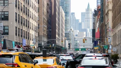
One way to address traffic congestion is to provide a bypass for vehicles around city traffic machinations. Ring roads, by definition, are meant to perform that function. In reality, they ignore the supply and demand model of traffic management.

The economic cost of traffic congestion in cities is significant. The Canadian Taxpayer Alliance for example states that in Toronto the cost of traffic amounts to more than one and a half billion dollars per year in lost productivity (not to mention additional consumption of greenhouse gases and resulting pollution and smog from inefficiently operated vehicles – which also bear economic costs).
One way to address traffic congestion is to provide a bypass for vehicles around city traffic machinations. A ring road, by definition, is to serve as exactly that. If there’s congestion on city roads, a ring road will provide an alternate route for traffic to circumnavigate the city.
But definitions can differ from reality. Does a ring road act as an orbital around the city? If there is urban development beyond it, by definition, it is not a ring road. If the road acts to increase capacity in the transportation network – building more roads to provide additional route choice to reducing traffic – then it is less a ring road and simply additional urban road infrastructure. However, increasing road supply does not equate to traffic alleviation.
I’ve written previously about the supply and demand model of traffic management. In brief, traffic is a function of demand. Too much demand exhausts the resource, in this case, roads. More resource is thus produced to accommodate demand; demand meets supply; repeat. More roads equal more traffic. In this case, a ring road produces more traffic. Or as expressed through a city planning model, a ring road – by adding more road capacity to the vehicular transportation network – allows the perpetuation of auto-centric planning.
Tim Miller writes in China’s Urban Billion, that ring roads allow the increase of “potential area for urban development in one stroke, as all land within an orbital will quickly become fair game for development.” Citing the World Bank, Miller continues, “What’s the best way to take land? … You draw a circle around the city and call it a ring road. It’s the most efficient way of circumscribing rural land. This means you have all the incentives for urban sprawl.” Anecdotally, Mr. Miller notes Beijing has five ring roads.
A demand for roads can be tied to the design of a community. Seeking efficiencies in a system designed for automobiles through the provision of additional road capacity does not resolve the underlying issue. If traffic congestion is to be ameliorated, supply shouldn’t be addressed. Address demand. By focusing on supply (i.e. building more roads), and not demand (i.e. augmenting a city to lessen vehicular demand), the production of an auto-centric city continues.
To ensconce my tongue deeply in my cheek, as city historian Lewis Mumford said, “Forget the damned motor car and build the cities for lovers and friends.”
Editor's Note: This post was revised on 11/15/2013

Agreement Keeps NYC Congestion Pricing Alive Through Summer
The tolling program will continue while a court considers the city’s lawsuit against the Trump administration.
NYC Congestion Pricing Goes Into Effect
The long-awaited congestion pricing program began on January 5.
Boston AI Pilot Optimizes Traffic Light Timing
The program has led to reductions in stop-and-go traffic of as much as 50 percent.

Alabama: Trump Terminates Settlements for Black Communities Harmed By Raw Sewage
Trump deemed the landmark civil rights agreement “illegal DEI and environmental justice policy.”

Planetizen Federal Action Tracker
A weekly monitor of how Trump’s orders and actions are impacting planners and planning in America.

The 120 Year Old Tiny Home Villages That Sheltered San Francisco’s Earthquake Refugees
More than a century ago, San Francisco mobilized to house thousands of residents displaced by the 1906 earthquake. Could their strategy offer a model for the present?

Trump Administration Could Effectively End Housing Voucher Program
Federal officials are eyeing major cuts to the Section 8 program that helps millions of low-income households pay rent.

NRDC Releases State Transportation Scorecard
The Getting Transportation Right report highlights which states are making the most progress on reducing transportation emissions and improving access to clean transportation options.

Study: How Urban Parks Can Support Biodiversity
Conservation and recreation can go hand in hand in urban green spaces designed to serve both humans and local wildlife.
Urban Design for Planners 1: Software Tools
This six-course series explores essential urban design concepts using open source software and equips planners with the tools they need to participate fully in the urban design process.
Planning for Universal Design
Learn the tools for implementing Universal Design in planning regulations.
Clanton & Associates, Inc.
Jessamine County Fiscal Court
Institute for Housing and Urban Development Studies (IHS)
City of Grandview
Harvard GSD Executive Education
Toledo-Lucas County Plan Commissions
Salt Lake City
NYU Wagner Graduate School of Public Service