


The U.S. Census Bureau uses a relatively crude definition of downtowns, complicating comparison between metros and opening up their findings to criticism. A new method of measuring downtowns via heat maps of job density aims to address this problem.
In a much debated report released by the Census Bureau last year that showed the resurgence of America's downtowns over the prior decade, a rather crude definition of "downtown" was used: "everything within a 2-mile radius of the local city hall".
As Emily Badger notes, this lack of precision "complicates the efforts of business improvement districts and city officials to back up what's supposed to be one of the great urban success stories of the 21st century (and a big topic at The Atlantic's CityLab summit on urban innovation in New York this week): the migration of employers and residents back downtown, redefining these places from dead zones where you one wouldn't want to be caught at night to full-service, 24-hour neighborhoods."
"With this perennial problem in mind, the Center City Philadelphia business improvement district is releasing a report [PDF] today prepared for the International Downtown Association that tries to offer a new way of counting jobs downtown, measuring where the people who hold them live, and enabling comparisons across cities."
"Surely some people will come up finer revisions of this definition..." adds Badger. "But, for now, the technique is an improvement from measuring how crows fly from City Hall."
FULL STORY: The Problem With Defining 'Downtown'

The Fallacy Behind the Downtown Growth Story
Wendell Cox delves into the latest numbers from the U.S. Census Bureau that have prompted some to herald a return to America's downtowns, and argues that reports of such population growth are vastly overblown.
Data Documents Divine Decade for Downtowns
Nate Berg looks at new data released by the U.S. Census Bureau that puts hard numbers behind what people across the country have observed: America's downtowns are booming again.
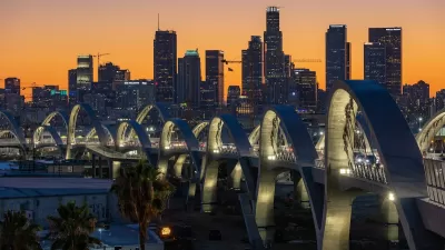
Downtown Los Angeles on the Rise: A Promising 2025
Fueled by new developments, cultural investments, and a growing dining scene, downtown Los Angeles is poised for significant growth in 2025, despite challenges from recent wildfires and economic uncertainties.

Alabama: Trump Terminates Settlements for Black Communities Harmed By Raw Sewage
Trump deemed the landmark civil rights agreement “illegal DEI and environmental justice policy.”

Planetizen Federal Action Tracker
A weekly monitor of how Trump’s orders and actions are impacting planners and planning in America.

The 120 Year Old Tiny Home Villages That Sheltered San Francisco’s Earthquake Refugees
More than a century ago, San Francisco mobilized to house thousands of residents displaced by the 1906 earthquake. Could their strategy offer a model for the present?

Ken Jennings Launches Transit Web Series
The Jeopardy champ wants you to ride public transit.

BLM To Rescind Public Lands Rule
The change will downgrade conservation, once again putting federal land at risk for mining and other extractive uses.

Indy Neighborhood Group Builds Temporary Multi-Use Path
Community members, aided in part by funding from the city, repurposed a vehicle lane to create a protected bike and pedestrian path for the summer season.
Urban Design for Planners 1: Software Tools
This six-course series explores essential urban design concepts using open source software and equips planners with the tools they need to participate fully in the urban design process.
Planning for Universal Design
Learn the tools for implementing Universal Design in planning regulations.
Clanton & Associates, Inc.
Jessamine County Fiscal Court
Institute for Housing and Urban Development Studies (IHS)
City of Grandview
Harvard GSD Executive Education
Toledo-Lucas County Plan Commissions
Salt Lake City
NYU Wagner Graduate School of Public Service