


The creator of a lauded guerrilla wayfinding project for Raleigh has launched a new website that allows users to duplicate his compelling signage for their communities.
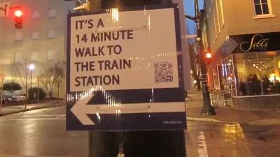
Last year, graduate student Matt Tomasulo launched a guerrilla wayfinding project in Raleigh, North Carolina that was so successful city leaders decided to adopt his idea. With the launch of Walk [Your City], you too can try your hand at getting your neighbors, and visitors, moving.
"The website is built around a handy tool that allows everyone to create custom street signs based on walkability," explains Stijn Hupkes. "Users draw a route between two points and the tool automatically calculates the walk or cycle minutes from A to B, as well as generates a good-looking sign. A QR code in the bottom corner links to a mobile website that displays the entire walking route."
"With the launch of the Walk [Your City] website, Tomasulo gives the rest of the world the opportunity to add a user-generated layer of wayfinding to cities."
FULL STORY: DIY Wayfinding Helps Growing Community Sense

City Puts an End to Guerrilla "Walk Raleigh" Campaign
A widely publicized guerrilla wayfinding campaign meant to give helpful guidance and encouragement to those exploring the city of Raleigh on foot has been quashed by the City Planning Director, report Chelsea Kellner and Bruce Siceloff.
What the ‘Walk Score’ Misses
A popular walkability assessment omits key factors that impact different demographics and can direct development resources to already wealthy neighborhoods.

The Natalist Case For Sprawl (And Why It Fails)
Some commentators defend anti-urban government policies such as exclusionary zoning on the basis that homeowning suburbanites have high birth rates. But this doesn't seem to be true in recent decades.

Alabama: Trump Terminates Settlements for Black Communities Harmed By Raw Sewage
Trump deemed the landmark civil rights agreement “illegal DEI and environmental justice policy.”

Planetizen Federal Action Tracker
A weekly monitor of how Trump’s orders and actions are impacting planners and planning in America.

The 120 Year Old Tiny Home Villages That Sheltered San Francisco’s Earthquake Refugees
More than a century ago, San Francisco mobilized to house thousands of residents displaced by the 1906 earthquake. Could their strategy offer a model for the present?

Ken Jennings Launches Transit Web Series
The Jeopardy champ wants you to ride public transit.

BLM To Rescind Public Lands Rule
The change will downgrade conservation, once again putting federal land at risk for mining and other extractive uses.

Indy Neighborhood Group Builds Temporary Multi-Use Path
Community members, aided in part by funding from the city, repurposed a vehicle lane to create a protected bike and pedestrian path for the summer season.
Urban Design for Planners 1: Software Tools
This six-course series explores essential urban design concepts using open source software and equips planners with the tools they need to participate fully in the urban design process.
Planning for Universal Design
Learn the tools for implementing Universal Design in planning regulations.
Clanton & Associates, Inc.
Jessamine County Fiscal Court
Institute for Housing and Urban Development Studies (IHS)
City of Grandview
Harvard GSD Executive Education
Toledo-Lucas County Plan Commissions
Salt Lake City
NYU Wagner Graduate School of Public Service