


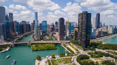
In an essay for Next City, Juan-Pablo Velez, member of the Chicago-based civic tech collective Open City, explains the rationale behind their latest project, which aims to make the city's zoning "digestible by humans."
Utilizing Chicago's open data push, Open City "has built tools that show who’s lobbying city hall, whether the city has plowed your snow-covered street and how the city’s economy is doing." For its latest project, Second City Zoning, Velez and his colleagues "set out to make make [sic] zoning—one of the most important forces shaping cities, and yet one of the most impenetrable— digestible by humans."
The site is what Velez describes as a "SimCity-flavored interactive map of Chicago’s zoning districts," that "allows residents to answer the question, 'what can I build on this property?'”
"Punch in an address to discover how a building is zoned, and see a human-readable description (written by us!) of what that actually means," he explains. "On top of the map, we’ve also distilled much of the zoning ordinance into a beginner-friendly cheat sheet, so residents can dig into the particulars of their property’s land use and density rules."
"Besides looking up a specific property, you can also use the app to explore Chicago’s zoning patterns and learn why the city’s urban landscape looks the way it does."
FULL STORY: SimCity for the Second City

‘Cut the Tape’ Report Takes Aim at Inefficiencies
A set of recommendations from the Chicago mayor’s office calls for streamlining city processes to stimulate more residential and commercial development.
Chicago's New Approach to Air Quality Includes Zoning Changes
Improved air quality can help achieve equitable economic growth, according to Chicago's newly announced Air Quality Agenda.

Zoning to Keep Manufacturing in Chicago
Planned manufacturing districts (PMDs) are a way to protect valuable land, but their effectiveness as an economic development strategy has been inconsistent.

Alabama: Trump Terminates Settlements for Black Communities Harmed By Raw Sewage
Trump deemed the landmark civil rights agreement “illegal DEI and environmental justice policy.”

Planetizen Federal Action Tracker
A weekly monitor of how Trump’s orders and actions are impacting planners and planning in America.

The 120 Year Old Tiny Home Villages That Sheltered San Francisco’s Earthquake Refugees
More than a century ago, San Francisco mobilized to house thousands of residents displaced by the 1906 earthquake. Could their strategy offer a model for the present?

Ken Jennings Launches Transit Web Series
The Jeopardy champ wants you to ride public transit.

BLM To Rescind Public Lands Rule
The change will downgrade conservation, once again putting federal land at risk for mining and other extractive uses.

Indy Neighborhood Group Builds Temporary Multi-Use Path
Community members, aided in part by funding from the city, repurposed a vehicle lane to create a protected bike and pedestrian path for the summer season.
Urban Design for Planners 1: Software Tools
This six-course series explores essential urban design concepts using open source software and equips planners with the tools they need to participate fully in the urban design process.
Planning for Universal Design
Learn the tools for implementing Universal Design in planning regulations.
Clanton & Associates, Inc.
Jessamine County Fiscal Court
Institute for Housing and Urban Development Studies (IHS)
City of Grandview
Harvard GSD Executive Education
Toledo-Lucas County Plan Commissions
Salt Lake City
NYU Wagner Graduate School of Public Service