


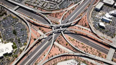
The State of New Hampshire has created an interactive online tool for its municipalities to examine the impacts of different land use scenarios, in the hopes of promoting smart growth. Geneva Faulkner describes how it works.
Created by RKG Associates, Placeways, and Urban Interactive Studio, under the auspices of the New Hampshire Office of Energy and Planning (NHOEP), the New Hampshire Cost of Sprawl Impact Model was developed to assist the state's planners, elected officials, and interested community members in understanding the fiscal impacts of land use decisions.
Users are able to analyze different types and scales of development for specific parcels in one of the state's 239 municipalities. Based on those selections, the tool produces information on expected "population and housing impact,
municipal fiscal cost, the percentages of land developed, and the
infrastructure needed for that particular scenario," writes Faulkner.
"Instead of having to perform calculations to determine floor area
ratios, the additional miles of road that would need to be built,
population growth and infrastructure, as well as other time-consuming
models, the Cost of Sprawl tool performs complex calculations
instantaneously, therefore allowing planners to spend less time
analyzing one particular scenario and more time understanding the
impacts of a variety of scenarios."
FULL STORY: Online Tool Helps New Hampshire Municipalities Examine the Cost of Sprawl

The Economic Defense of Sprawl (And What's Wrong With It)
Defenders of suburban expansion argue that government should build more roads in order to open up more land for housing. What's wrong with that argument?
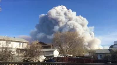
What Goes Together? Sprawl and Destructive Wildfires
Wildfires tend to start at the Wildland-Urban Interface: those border zones between cities and the open land surrounding them. Keeping the lid on sprawl, it can be argued, would tame the inferno.
American Suburbia Transplanted to Beijing
Chinese and Indian cities have been quick to welcome housing developments modeled on North American suburbs, including "Orange County" and "Vancouver Forest" in Beijing. This globalized sprawl perpetuates all the ills of our own.

Alabama: Trump Terminates Settlements for Black Communities Harmed By Raw Sewage
Trump deemed the landmark civil rights agreement “illegal DEI and environmental justice policy.”

Planetizen Federal Action Tracker
A weekly monitor of how Trump’s orders and actions are impacting planners and planning in America.

The 120 Year Old Tiny Home Villages That Sheltered San Francisco’s Earthquake Refugees
More than a century ago, San Francisco mobilized to house thousands of residents displaced by the 1906 earthquake. Could their strategy offer a model for the present?

Ken Jennings Launches Transit Web Series
The Jeopardy champ wants you to ride public transit.

BLM To Rescind Public Lands Rule
The change will downgrade conservation, once again putting federal land at risk for mining and other extractive uses.

Indy Neighborhood Group Builds Temporary Multi-Use Path
Community members, aided in part by funding from the city, repurposed a vehicle lane to create a protected bike and pedestrian path for the summer season.
Urban Design for Planners 1: Software Tools
This six-course series explores essential urban design concepts using open source software and equips planners with the tools they need to participate fully in the urban design process.
Planning for Universal Design
Learn the tools for implementing Universal Design in planning regulations.
Clanton & Associates, Inc.
Jessamine County Fiscal Court
Institute for Housing and Urban Development Studies (IHS)
City of Grandview
Harvard GSD Executive Education
Toledo-Lucas County Plan Commissions
Salt Lake City
NYU Wagner Graduate School of Public Service