


From black flight to Asian invasion, Mark Wilson offers his take on a stunning map that lays out the changing demography of Los Angeles.
Eric Fischer earned widespread recognition in 2010 for assembling census data into demographic maps in "Race and Ethnicity (2000)", a project as artistic as it is cartographic. Now, with 2010 Census data in hand, Fischer zooms in to give us a closer look at how Los Angeles has changed in the last twenty years.
In particular, Wilson points to the explosion of the Asian population in Monterey Park, "the first mainland American city with an Asian majority." He also points to the exodus of blacks out of Compton, "a calling card for an entire movement of black hip-hop artists in the '90s," supplanted by an influx of Latinos.
"If there's one thing that's particularly depressing about this map," Wilson opines, "it's not really found in a story of which race ends up where, but in the fact that, over 20 years of so-called progress, these segregated pockets aren't melding. Rather, they're shifting in color."
FULL STORY: Infographic Shows The Shifting Racial Makeup of L.A. 20 Years After Rodney King

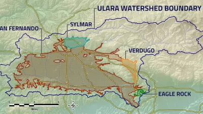
Superfund Project to Deliver Massive Water Supply Boon to Los Angeles
The semi-arid region of Los Angeles is often mistaken for a desert, but the local water supply is also constrained by the environmental sins of the 20th century. The water supply equation of Los Angeles will soon change, however.
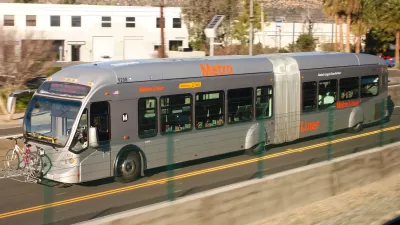
Funding for Two Transit Projects Approved for the Valley in Los Angeles
Local funding for a new light rail line and upgrades to the G Line (née Orange Line) bus rapid transit route have been approved for the San Fernando Valley in Los Angeles.

L.A.'s San Fernando Valley $909 Million Closer to Light Rail
The last time rail transit crossed L.A.'s San Fernando Valley was in the early 1950s.

Alabama: Trump Terminates Settlements for Black Communities Harmed By Raw Sewage
Trump deemed the landmark civil rights agreement “illegal DEI and environmental justice policy.”

Planetizen Federal Action Tracker
A weekly monitor of how Trump’s orders and actions are impacting planners and planning in America.

Why Should We Subsidize Public Transportation?
Many public transit agencies face financial stress due to rising costs, declining fare revenue, and declining subsidies. Transit advocates must provide a strong business case for increasing public transit funding.

Understanding Road Diets
An explainer from Momentum highlights the advantages of reducing vehicle lanes in favor of more bike, transit, and pedestrian infrastructure.

New California Law Regulates Warehouse Pollution
A new law tightens building and emissions regulations for large distribution warehouses to mitigate air pollution and traffic in surrounding communities.

Phoenix Announces Opening Date for Light Rail Extension
The South Central extension will connect South Phoenix to downtown and other major hubs starting on June 7.
Urban Design for Planners 1: Software Tools
This six-course series explores essential urban design concepts using open source software and equips planners with the tools they need to participate fully in the urban design process.
Planning for Universal Design
Learn the tools for implementing Universal Design in planning regulations.
Caltrans
Smith Gee Studio
Institute for Housing and Urban Development Studies (IHS)
City of Grandview
Harvard GSD Executive Education
Toledo-Lucas County Plan Commissions
Salt Lake City
NYU Wagner Graduate School of Public Service