


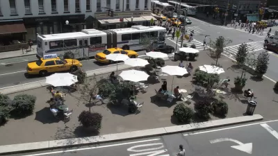
The New York Times' architecture critic, Michael Kimmelman, reviews a new exhibition exploring the history of the city's grid and streets.
"After all, before it could rise into the sky, Manhattan had to create the streets, avenues and blocks that support the skyscrapers. The grid was big government in action, a commercially minded boon to private development and, almost despite itself, a creative template. With 21st-century problems - environmental, technological, economic and social - now demanding aggressive and socially responsible leadership, the exhibition is a kind of object lesson.
Simeon De Witt, Gouverneur Morris and John Rutherfurd were entrusted with planning the city back in 1811. New York huddled mostly south of Canal Street, but it was booming, its population having tripled to 96,373 since 1790 thanks to the growing port. Civic boosters predicted that 400,000 people would live in the city by 1860. They turned out to be half-right. New York topped 800,000 before the Civil War.
The planners proposed a grid for this future city stretching northward from roughly Houston Street to 155th Street in the faraway heights of Harlem. It was in many respects a heartless plan. There were virtually no parks or plazas. The presumption was that people would gravitate east and west along the numbered streets to the rivers when they wanted open space and fresh air, and not spend lots of time moving north or south. That partly explains why there were only a dozen avenues."
The exhibit, The Greatest Grid: The Master Plan of Manhattan, 1811-2011, is currently showing at the Museum of the City of New York.
Thanks to Nate Berg
FULL STORY: The Grid at 200: Lines That Shaped Manhattan

Embracing the Future of City Streets
Streets will have to evolve, again.
A Grid Balancing Act for Vibrant, Varied, and Sustainable Places
An analysis of three essential attributes of urban grids reveals a preferred layout for the desired effect of a vibrant, active community.
New York's Streets Provide "Platform for Social Activism"
Justin Davidson ruminates on the great strides Janette Sadik-Khan and New York's Department of Transportation have made in reforming the city's streets. As much as they've accomplished, the transformation remains a work in progress.

Alabama: Trump Terminates Settlements for Black Communities Harmed By Raw Sewage
Trump deemed the landmark civil rights agreement “illegal DEI and environmental justice policy.”

Planetizen Federal Action Tracker
A weekly monitor of how Trump’s orders and actions are impacting planners and planning in America.

The 120 Year Old Tiny Home Villages That Sheltered San Francisco’s Earthquake Refugees
More than a century ago, San Francisco mobilized to house thousands of residents displaced by the 1906 earthquake. Could their strategy offer a model for the present?

Ken Jennings Launches Transit Web Series
The Jeopardy champ wants you to ride public transit.

BLM To Rescind Public Lands Rule
The change will downgrade conservation, once again putting federal land at risk for mining and other extractive uses.

Indy Neighborhood Group Builds Temporary Multi-Use Path
Community members, aided in part by funding from the city, repurposed a vehicle lane to create a protected bike and pedestrian path for the summer season.
Urban Design for Planners 1: Software Tools
This six-course series explores essential urban design concepts using open source software and equips planners with the tools they need to participate fully in the urban design process.
Planning for Universal Design
Learn the tools for implementing Universal Design in planning regulations.
Clanton & Associates, Inc.
Jessamine County Fiscal Court
Institute for Housing and Urban Development Studies (IHS)
City of Grandview
Harvard GSD Executive Education
Toledo-Lucas County Plan Commissions
Salt Lake City
NYU Wagner Graduate School of Public Service