


A new land use study based on the 2008 "comp plans" data reveals a significant shift toward mixed-use and transit-oriented developments (TODs) in the Twin Cities seven-county metro area.
The 2030 projection for mixed-use in the Minneapolis-Saint Paul region is 55,000 acres, which represents a huge jump from less than 5,700 acres in 2010. Similarly, the 2030 land use estimate for "transitway corridor" is reported at 22.7%, also showing a marked increase from 8.4% in 2010.
There is a "statistically significant trend of more people in the seven-county metro region moving closer to the central core of cities and to more accessible transit options in higher-density areas. The land-use data also project a fast acceleration of the shift in the next 20 years," writes Bill Clements for Finance and Commerce.
"As we come out of this recession, it will be very interesting to see how the market responds. Is that a permanent shift toward more permanent attached and smaller single-family detached housing?," asks the Met Council analyst John Kari in the article.
FULL STORY: Culture change or fad? Twin Cities population shifts toward central core


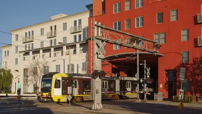
North Texas Transit Leaders Tout Benefits of TOD for Growing Region
At a summit focused on transit-oriented development, policymakers discussed how North Texas’ expanded light rail system can serve as a tool for economic growth.

Connecticut Assembly to Reconsider TOD Bill
The ‘Work, Live, Ride’ bill would prioritize funding for designated transit-oriented zones to encourage denser development near transit.
California Bill Aims to Boost TOD
A bill proposed by Sen. Scott Wiener would exempt transit agencies from zoning rules near ‘high-quality’ transit stops and allow denser transit-oriented development.

Alabama: Trump Terminates Settlements for Black Communities Harmed By Raw Sewage
Trump deemed the landmark civil rights agreement “illegal DEI and environmental justice policy.”

Planetizen Federal Action Tracker
A weekly monitor of how Trump’s orders and actions are impacting planners and planning in America.

The 120 Year Old Tiny Home Villages That Sheltered San Francisco’s Earthquake Refugees
More than a century ago, San Francisco mobilized to house thousands of residents displaced by the 1906 earthquake. Could their strategy offer a model for the present?

Ken Jennings Launches Transit Web Series
The Jeopardy champ wants you to ride public transit.

BLM To Rescind Public Lands Rule
The change will downgrade conservation, once again putting federal land at risk for mining and other extractive uses.

Indy Neighborhood Group Builds Temporary Multi-Use Path
Community members, aided in part by funding from the city, repurposed a vehicle lane to create a protected bike and pedestrian path for the summer season.
Urban Design for Planners 1: Software Tools
This six-course series explores essential urban design concepts using open source software and equips planners with the tools they need to participate fully in the urban design process.
Planning for Universal Design
Learn the tools for implementing Universal Design in planning regulations.
Clanton & Associates, Inc.
Jessamine County Fiscal Court
Institute for Housing and Urban Development Studies (IHS)
City of Grandview
Harvard GSD Executive Education
Toledo-Lucas County Plan Commissions
Salt Lake City
NYU Wagner Graduate School of Public Service