


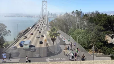
Peak period pricing on the Bay Bridge, enacted by the regional Bay Area Toll Authority on July 1, is the first application of congestion pricing for driving in the Bay Area. Officials in San Francisco feel the outcome is favorable for their project.
Make no mistake - these are two separate projects by two different agencies - both involving different applications of congestion pricing. However, the goals are similar - shift driving to off-peak times, and shifting drivers from single occupant vehicles to alternatives.
"San Francisco officials are watching closely to see if higher tolls on the Bay Bridge might help the city make the case for charging fees to drive into downtown in high-traffic periods -- and so far, the evidence is promising.
(E)xecutives from the San Francisco County Transportation Authority planning to bring a citywide congestion pricing plan before the Board of Supervisors this fall were encouraged by the trend toward public transit."
"We do think that it is too early to draw any conclusions," SFCTA deputy director for planning Tilly Chang said. "But the general indication is that people are shifting their behavior in some way, which is the goal of congestion pricing."
Thanks to Climate Plan
FULL STORY: Bay Bridge tolls a boost for congestion pricing?

Planning Underway for New Bay Bridge Bike Path, and a Second Transbay BART Tube
In a distant and expensive future, there are two new ways to get across the San Francisco Bay without a car. One will have a much better view.
Recommendations for Improving the Bay Area's Busiest Commute
One of the nation's busiest commute corridors will get a lot busier in coming decades with no large infrastructure investment in sight. SPUR has some ideas about how the East Bay to San Francisco corridor can be improved right now.
California Lawmakers Withdraw Connect Bay Area Act
The proposal would have merged the Bay Area’s 27 transit agencies into one regional entity.

Alabama: Trump Terminates Settlements for Black Communities Harmed By Raw Sewage
Trump deemed the landmark civil rights agreement “illegal DEI and environmental justice policy.”

Planetizen Federal Action Tracker
A weekly monitor of how Trump’s orders and actions are impacting planners and planning in America.

The 120 Year Old Tiny Home Villages That Sheltered San Francisco’s Earthquake Refugees
More than a century ago, San Francisco mobilized to house thousands of residents displaced by the 1906 earthquake. Could their strategy offer a model for the present?

Ken Jennings Launches Transit Web Series
The Jeopardy champ wants you to ride public transit.

BLM To Rescind Public Lands Rule
The change will downgrade conservation, once again putting federal land at risk for mining and other extractive uses.

Indy Neighborhood Group Builds Temporary Multi-Use Path
Community members, aided in part by funding from the city, repurposed a vehicle lane to create a protected bike and pedestrian path for the summer season.
Urban Design for Planners 1: Software Tools
This six-course series explores essential urban design concepts using open source software and equips planners with the tools they need to participate fully in the urban design process.
Planning for Universal Design
Learn the tools for implementing Universal Design in planning regulations.
Clanton & Associates, Inc.
Jessamine County Fiscal Court
Institute for Housing and Urban Development Studies (IHS)
City of Grandview
Harvard GSD Executive Education
Toledo-Lucas County Plan Commissions
Salt Lake City
NYU Wagner Graduate School of Public Service