


MIT researcher Jeffrey Warren has just released the latest version of Cartagen, a software platform for interactive mapping. Julia Galef takes a look.
"[Cartagen] uses Google's geographic data as a starting point, but lets people choose which features to include on their maps-streets, parks, churches, and so on-and how to visually represent those features, creating their maps from the ground up. Users can also add new data, which Cartagen can represent not just as points on the map but as outlines, polygons, overlapping shaded clouds-the possibilities are still expanding as Warren's team brainstorms new potential uses for its creation."
FULL STORY: Keeping Cartography Alive


New Book Shows How Geographic Technology Tackles Global Challenges
In his new book, Jack Dangermond explores the transformative impact of GIS technology in solving global challenges through spatial data, highlighting its widespread application across sectors and its potential to design sustainable futures.
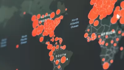
Visualizing the Coronavirus Pandemic
Mapping of the crisis is producing a fascinating and important trove of cartographic records.
Changes to Google Maps Don't Necessarily Equal Good Cartography
Google Maps has changed a lot since its quick rise to ubiquity. An intrepid blogger digs into the nitty gritty of how the mapping platform has changed, and the consequences of Google's cartography for how the public perceives the world.

Alabama: Trump Terminates Settlements for Black Communities Harmed By Raw Sewage
Trump deemed the landmark civil rights agreement “illegal DEI and environmental justice policy.”

Study: Maui’s Plan to Convert Vacation Rentals to Long-Term Housing Could Cause Nearly $1 Billion Economic Loss
The plan would reduce visitor accommodation by 25% resulting in 1,900 jobs lost.

Why Should We Subsidize Public Transportation?
Many public transit agencies face financial stress due to rising costs, declining fare revenue, and declining subsidies. Transit advocates must provide a strong business case for increasing public transit funding.

Paris Bike Boom Leads to Steep Drop in Air Pollution
The French city’s air quality has improved dramatically in the past 20 years, coinciding with a growth in cycling.

Why Housing Costs More to Build in California Than in Texas
Hard costs like labor and materials combined with ‘soft’ costs such as permitting make building in the San Francisco Bay Area almost three times as costly as in Texas cities.

San Diego County Sees a Rise in Urban Coyotes
San Diego County experiences a rise in urban coyotes, as sightings become prevalent throughout its urban neighbourhoods and surrounding areas.
Urban Design for Planners 1: Software Tools
This six-course series explores essential urban design concepts using open source software and equips planners with the tools they need to participate fully in the urban design process.
Planning for Universal Design
Learn the tools for implementing Universal Design in planning regulations.
Smith Gee Studio
Alamo Area Metropolitan Planning Organization
City of Santa Clarita
Institute for Housing and Urban Development Studies (IHS)
City of Grandview
Harvard GSD Executive Education
Toledo-Lucas County Plan Commissions
Salt Lake City
NYU Wagner Graduate School of Public Service