


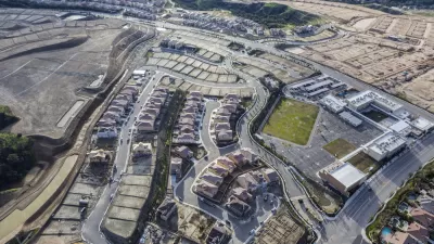
New research from the University of Cincinnati shows that nearly a third of U.S. schools are located within a quarter-mile of major highways, posing a significant air pollution threat to students.
"UC researchers have found that more than 30 percent of American public schools are within 400 meters, or a quarter mile, of major highways that consistently serve as main truck and traffic routes."
"Research has shown that proximity to major highways-and thus environmental pollutants, such as aerosolizing diesel exhaust particles-can leave school-age children more susceptible to respiratory diseases later in life."
"To protect the health of young children with developing lungs, new schools should be built further from major highways, says Sergey Grinshpun, PhD, principal investigator of the study and professor of environmental health at UC."
"'Health risk can be mitigated through proper urban planning, but that doesn't erase the immediate risk to school-age children attending schools that are too close to highways right now,' he adds. 'Existing schools should be retrofitted with air filtration systems that will reduce students' exposure to traffic pollutants.'"
FULL STORY: Many U.S. Public Schools in ‘Air Pollution Danger Zone’

Study: Kids Do Worse in Schools Near Traffic
Moving to a school with higher levels of traffic pollution could impact students' academic performance, according to new research.
Pollution Does Discriminate in Orlando’s Parramore Neighborhood
Poor air quality has decimated the health of residents in this predominantly black community ringed by highways.
More on those Freeway-Adjacent Affordable Housing Developments
The Los Angeles Times follows-up an earlier article on the dangers of building too close to freeways. It's a trade-off that the California Air Resources Board acknowledged last April with new guidelines that recognize the dire need for housing.

Alabama: Trump Terminates Settlements for Black Communities Harmed By Raw Sewage
Trump deemed the landmark civil rights agreement “illegal DEI and environmental justice policy.”

Planetizen Federal Action Tracker
A weekly monitor of how Trump’s orders and actions are impacting planners and planning in America.

The 120 Year Old Tiny Home Villages That Sheltered San Francisco’s Earthquake Refugees
More than a century ago, San Francisco mobilized to house thousands of residents displaced by the 1906 earthquake. Could their strategy offer a model for the present?

Ken Jennings Launches Transit Web Series
The Jeopardy champ wants you to ride public transit.

BLM To Rescind Public Lands Rule
The change will downgrade conservation, once again putting federal land at risk for mining and other extractive uses.

Indy Neighborhood Group Builds Temporary Multi-Use Path
Community members, aided in part by funding from the city, repurposed a vehicle lane to create a protected bike and pedestrian path for the summer season.
Urban Design for Planners 1: Software Tools
This six-course series explores essential urban design concepts using open source software and equips planners with the tools they need to participate fully in the urban design process.
Planning for Universal Design
Learn the tools for implementing Universal Design in planning regulations.
Clanton & Associates, Inc.
Jessamine County Fiscal Court
Institute for Housing and Urban Development Studies (IHS)
City of Grandview
Harvard GSD Executive Education
Toledo-Lucas County Plan Commissions
Salt Lake City
NYU Wagner Graduate School of Public Service