


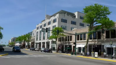
National Trust Main Street Center Program Officer Nick Kalogersis, AICP gives a primer on form-based zoning and its relavance to traditional commercial district revitalization.
For most of us in the Main Street revitalization field, addressing the inadequacies of our local zoning code has become increasingly important. For instance, local zoning may forbid certain land uses, such as residential units on upper floors, and it may lack the necessary building design standards to ensure that new construction fits in and complements the existing building fabric. When it comes to dealing with the design of new buildings, Main Street communities may develop design guidelines or adopt design overlay districts as additions to the local zoning code. Design guidelines and design review procedures, especially if they are mandatory, can effectively ensure that new buildings contribute to the district's pedestrian orientation and overall sense of scale and urban design.
However, design guidelines used today by many Main Street communities often focus exclusively on the rehabilitation of existing historic commercial buildings rather than including new construction. And, often, their design review procedures, which require builders and developers to seek project approval from a review commission, often lengthens the time it take to get a building project started. More often than not, a design review process may not always guarantee that the best building design is built since the goal of most design guidelines is to keep the worst buildings from being built.
So, what does a Main Street program do when planning to reform its local zoning code? How can we make zoning more effective when dealing with new construction and in maximizing the number of land uses in Main Street districts? How do we really know what is allowed and not allowed?
Thanks to Luke VanBelleghem
FULL STORY: Form-Based Zoning on Main Street


Code Score: A New Aid for Aligning Policy and Vision With Outcomes
A compendium of benefits of walkable urban places, put together by Hazel Borys and Kaid Benfield.
Code Hackathon: What Can Go Wrong With Form-Based Codes?
Top problems with form-based codes, and how to fix them.
A New Path to Code Reform
The Users’ Guide to Code Reform leads planners through the code reform process, providing tools for governments lacking the capacity to develop a full form-based code. Susan Henderson and Matt Lambert hit the high points.

Alabama: Trump Terminates Settlements for Black Communities Harmed By Raw Sewage
Trump deemed the landmark civil rights agreement “illegal DEI and environmental justice policy.”

Planetizen Federal Action Tracker
A weekly monitor of how Trump’s orders and actions are impacting planners and planning in America.

Why Should We Subsidize Public Transportation?
Many public transit agencies face financial stress due to rising costs, declining fare revenue, and declining subsidies. Transit advocates must provide a strong business case for increasing public transit funding.

Understanding Road Diets
An explainer from Momentum highlights the advantages of reducing vehicle lanes in favor of more bike, transit, and pedestrian infrastructure.

New California Law Regulates Warehouse Pollution
A new law tightens building and emissions regulations for large distribution warehouses to mitigate air pollution and traffic in surrounding communities.

Phoenix Announces Opening Date for Light Rail Extension
The South Central extension will connect South Phoenix to downtown and other major hubs starting on June 7.
Urban Design for Planners 1: Software Tools
This six-course series explores essential urban design concepts using open source software and equips planners with the tools they need to participate fully in the urban design process.
Planning for Universal Design
Learn the tools for implementing Universal Design in planning regulations.
Caltrans
Smith Gee Studio
Institute for Housing and Urban Development Studies (IHS)
City of Grandview
Harvard GSD Executive Education
Toledo-Lucas County Plan Commissions
Salt Lake City
NYU Wagner Graduate School of Public Service