


How could a new chamber of commerce algorithm drive decisions about employer locations, improve mobility of workers, while reducing pollution accruing from longer daily work trips? The answer is simple, says the chief economist of the Greater Dallas Chamber, Lyssa Jenkens, “You change the data system to deliver information people never got before.”
How could a new chamber of commerce algorithm drive decisions about employer locations, improve mobility of workers, while reducing pollution accruing from longer daily work trips? The answer is simple, says the chief economist of the Greater Dallas Chamber, Lyssa Jenkens, "You change the data system to deliver information people never got before."
For a long time, Jenkens explains, if an employer – let's say it's a supplier to Texas Instruments that wants to be within easy delivery distance of TI, and they need 15 engineers and 10 people with specific technical skills, "We could tell them, county by county, a general occupational count. But we've always known that political jurisdictions are an artificial way of organizing data, and may even distort the picture of where people with different occupational skills are living."
Now, with a fresh black box for number-crunching, rooted in data from the U.S. census, updated by the bureau's annual American Community Survey and combined with GIS technology at the North Central Texas Council of Governments (NCTCOG), Jenkens can tell a potential employer how many engineers live within a 5 or 10 or 15-mile radius of any site where an employer wants to locate. The database sorts for 110 different occupations. The next short step will tweak the NCTCOG's algorithm to show travel times, which, as congestion in the Dallas-Fort Worth region worsens (yes, it can still get worse), will enable employer to operate with a higher degree of confidence that their staff can get to work without exhausting their emotional energies.
There are two key things at work here. First, Dallas, following the lead of Denver, was one of the earliest large metropolitan areas to put the traditional fractionating rivalries to the side and organize its economic development strategy around the real region. And it is a big region. The twelve-county Dallas Fort Worth "metroplex" has a population of more than six million people and occupies an area larger than New Hampshire. When DFW airport was built in the early 1970s, it quickly became the new epicenter, drawing the Dallas and Fort Worth communities together into a continuous stream of urban development. Today, the Dallas Chamber serves as a single point of contact for employers considering the region and is as likely to refer them to Plano or Irving or Fort Worth, as Dallas
But this data-breakthrough isn't just about employers and their location decisions. Think about the implications for public decisions about land use, about where roads should (and should not) be built, about potential for reducing miles driven to work every day. About where transit corridors – and Dallas is among the most aggressive regions in the U.S. in building a network of rail transit – can best provide an alternative to cars.
I asked Jenkens about the proprietary potential of her black box. She quickly agreed that this was valuable intellectual property, and that with some work perhaps her chamber organization could nail down their rights and set up a stream of licensing revenue. But, she said, it's a lot more important for this potential to spread around the country. Once she's worked out the kinks in the system, look for her to find ways to spread this data technology to chambers all over the country, most likely through the network of the Association of Chamber of Commerce Executives (ACCE). Check out the mapping at http://maps.dallaschamber.org/map.asp.
Once planners get their hands on this data-set, and find ways to graft it into their fast-developing capabilities with Google Earth GIS layers, land-use and transportation planning will have graduated to the first and fast-evolving stages of 21st century potentials.


Maine Law Promotes Smart Growth
New state legislation encourages cities to plan around ‘smart growth’ principles to preserve farmland and open space, and use infill development to build more housing.
A Better Understanding of Smart Growth Benefits
Smart Growth creates compact, multimodal communities where residents consume less land, drive less, and rely more on non-auto modes. Planners have important stories to tell about the benefits of Smart Growth.
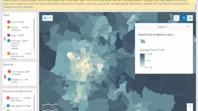
Getting to Work: New Commute Duration Heatmaps
The Mineta Transportation Institute's new interactive website produces heatmaps that illustrate commute duration—the number of minutes that workers spend traveling to their jobs—plus related information, for most U.S. communities.

Alabama: Trump Terminates Settlements for Black Communities Harmed By Raw Sewage
Trump deemed the landmark civil rights agreement “illegal DEI and environmental justice policy.”

Planetizen Federal Action Tracker
A weekly monitor of how Trump’s orders and actions are impacting planners and planning in America.

The 120 Year Old Tiny Home Villages That Sheltered San Francisco’s Earthquake Refugees
More than a century ago, San Francisco mobilized to house thousands of residents displaced by the 1906 earthquake. Could their strategy offer a model for the present?

Ken Jennings Launches Transit Web Series
The Jeopardy champ wants you to ride public transit.

BLM To Rescind Public Lands Rule
The change will downgrade conservation, once again putting federal land at risk for mining and other extractive uses.

Indy Neighborhood Group Builds Temporary Multi-Use Path
Community members, aided in part by funding from the city, repurposed a vehicle lane to create a protected bike and pedestrian path for the summer season.
Urban Design for Planners 1: Software Tools
This six-course series explores essential urban design concepts using open source software and equips planners with the tools they need to participate fully in the urban design process.
Planning for Universal Design
Learn the tools for implementing Universal Design in planning regulations.
Clanton & Associates, Inc.
Jessamine County Fiscal Court
Institute for Housing and Urban Development Studies (IHS)
City of Grandview
Harvard GSD Executive Education
Toledo-Lucas County Plan Commissions
Salt Lake City
NYU Wagner Graduate School of Public Service